Brisbane River Heritage Trail
Wind back time on the water and immerse yourself in Brisbane City Council’s first heritage trail by CityCat.
Designed to start at the Northshore Hamilton ferry terminal and end at the UQ St Lucia ferry terminal, the complete self-guided trail is about 1.5 hours one-way (3 hours return) and is the best way to experience the full heritage trail. However, you can enjoy all or parts of the trail from any CityCat ferry terminal along the route.
Self-guided heritage trail
- Explore all 32 places from your river vantage points.
- Choose a themed selection to see places related to river trade, crossings, living on the river, the Second World War, or Brisbane Tuff.
- Hop on or off to access other heritage trails through the city and South Bank.
- Use navigational hints to find places when travelling upstream or downstream.
- Listen to historical narration and re-enactments about select places.
Find all heritage places on the map below, or download the Brisbane River Heritage Trail (Word - 61Mb) guide, which includes additional images.
Brisbane River Heritage Trail map
Show or hide map features
Suburb
Heritage Places
Image credit: State Library of Queensland
Introduction
Brisbane is known as the River City for its position on the Brisbane River, the longest in South East Queensland and an iconic city centrepiece.
Since convict settlement, the river has been a vital artery for commerce and development, but also an adversary bringing devastating floods with major flooding occurring in 1824–25, 1841, 1893, 1974, 2011 and 2022.
Despite these setbacks, Brisbane flourished as Queensland’s capital city on the banks of a river, earning its place as an integral part of local history.
Explore Brisbane’s evolution in central themes along the river trail to encounter fascinating and sometimes little-known stories about places, features and landmarks that pay tribute to the city’s past.
Read more
Read more
In 1824, the founding of the Moreton Bay penal settlement heralded the beginning of the European presence in Queensland and the displacement of the Aboriginal people in the area.
The first penal settlement at Moreton Bay was established at Redcliffe in 1824 but moved to the present Central Business District (CBD) site in 1825 where there was a better water supply, fewer mosquitoes, and safer anchorage. The convict settlement operations had almost ceased by 1839 and in 1842 Moreton Bay was officially opened for free settlement as part of the colony of New South Wales.
Today Brisbane is known as the River City. The Brisbane River is the longest river in South East Queensland and forms an iconic city centrepiece. Since convict settlement, it has been a vital artery for commerce and development, but also an adversary bringing devastating floods with major flooding occurring in 1824–25, 1841, 1893, 1974, 2011 and 2022. Despite these setbacks, Brisbane has flourished as Queensland’s capital city on the banks of a river earning its place as an integral part of local history.
Explore Brisbane’s evolution in central themes along the river trail to encounter fascinating and sometimes little-known stories about places, features and landmarks that pay tribute to the city’s past.
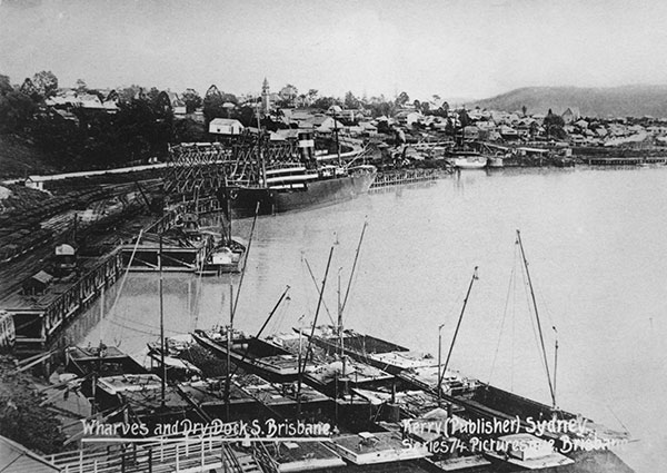
River trade
The Brisbane River is peaceful today but in the late 19th Century and early 20th Century it was bustling with steam ships and sailing vessels moving goods and passengers in and out of the city. Docks lined the CBD and South Brisbane, a grand customs house was built to oversee the paying of duties on goods, and the imposing Woolstores were built at the suburb of Teneriffe to serve a thriving wool export industry centred on the Darling Downs. Barges travelled the river, unloading coal from Ipswich west of Brisbane to power stations on the riverbank.
Look out for places, including:
- Woolstores
- CSR Refinery (former)
- Howard Smith Wharves
- Brisbane Customs House (former)
- Gas Stripping Tower
- Colmslie Beach Reserve (site of Swifts Meat Works).
River crossings
From early settlement days, the Brisbane River divided the city and distinctive ‘northside’ and ‘southside’ characters developed. Established in 1888, South Brisbane was a separate municipality and the city’s original commercial hub and the CBD formed around the old penal and government precincts. It was only in 1925 that the City of Brisbane was formed through the amalgamation of the former City of Brisbane, the City of South Brisbane and 18 neighbouring towns and shires.
Overcoming the physical barrier of the river was important for families and businesses and challenging at times for the people of Brisbane. In 1925, one of the first actions of the newly created City of Brisbane was to launch a commission to investigate ways of improving bridge and ferry connections. Locals wanting to cross the river initially used small steam ferries and rowboats, later graduating to larger timber ferries. Along the heritage trail, you will pass under a series of bridges from various eras and see historic terminals built for early wooden ferries.
Look out for places, including:
- Bulimba ferry terminal
- Canning Bridge and Reserve
- Story Bridge
- Former Victoria Bridge Abutments
- William Jolly Bridge.
Brisbane’s bedrock
Parts of Brisbane sit on Brisbane Tuff (pronounced ‘toof’), a type of bedrock up to 50 m deep. Sometimes incorrectly called Brisbane Porphyry, the rock was formed more than 200 million years ago during volcanic eruptions from a mixture of volcanic ash and pyroclastic flows. Brisbane Tuff varies in colour from pink, green and tan, to purple and a blue-grey shade. It has been used as a building material since the start of the Brisbane penal settlement and the impact of Tuff mining can be seen along the banks of the Brisbane River. You can see evidence of old quarries where the river has cut through the beds of rock.
Look out for places, including:
- Hamilton retaining walls
- Kangaroo Point Cliffs
- Former Victoria Bridge Abutments.
Living on the River
With cooling breezes and sweeping views, many of Brisbane’s finest residences have been built on hillsides along the river. These houses showcase a range of architectural styles dating back to the 19th Century. One of the largest collections of mansions and stylish apartments can be seen on the hill at Hamilton. This place became known as Toorak Hill after former Queensland Premier Sir James Dickson built the villa Toorak House on the hillcrest c.1865. Of all the beautiful colonial riverfront mansions, the most significant is Newstead House built in 1846, the oldest surviving residence in Brisbane. It has a spectacular position and represents the prosperity of the Queensland colony in the 19th Century. Early life on the river is also represented by several other important homes and apartments.
Look out for places, including:
- Hamilton Villas
- Newstead House
- Shafston House
- Gleneagles
- Brisbane Travelodge (former)
- Cliffside Apartments
- Home (also known as Lamb House)
- Cook Terrace.
The Second World War
During the Second World War from 1942–45, General Douglas MacArthur made Brisbane the headquarters of the Allied war campaign in the South West Pacific. Brisbane hosted many American and Allied troops, a presence that changed the city culture from its quiet, colonial past as an offshoot of Great Britain. The river played a vital role in wartime military activities including a substantial boat-building industry that made use of the docks and other locations on and near the Brisbane River. Several famous American submarines were also based at New Farm.
Look out for places, including:
- Woolstores
- Limbless Soldiers’ Bowling Club (former)
- Evans Deakin Dry Dock (former)
- Naval Stores (former)
- South Brisbane Dry Dock.
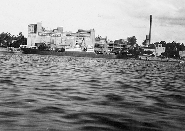
1. Colmslie Beach Reserve – 152 Colmslie Road, Murarrie
Once one of Queensland’s most important industrial sites, it is hard to believe the beautiful Colmslie Beach Reserve with its relaxed riverside setting and grounds full of mature trees was, until the 1980s, the site of a busy Brisbane abattoir.
Read more
Read more
Swifts Meat Works, originally an American meat packing company, began business on the banks of the Brisbane River in 1913. It quickly established its role in the local economy as one of the largest industrial operations and employers in Queensland. By 1928, at least 530 employees were on the payroll.
The complex included a wharf for stock delivery and export, large holding yards and a railway siding to facilitate stock and passenger transport. The meat works was credited with providing the only passenger rail service for its workers in Brisbane.
The gardens were a particular source of pride for the meat works, with beds blooming with roses, poppies and sweet peas. Jacaranda and African Tulip trees were planted in an avenue and can still be seen in the reserve today.
Meat processing works were a dominant industry in the Murarrie-Cannon Hill riverfront areas in the early 20th Century. From 1907, Thomas Borthwick & Sons operated another large meat works just downstream.
The 1930s brought big changes to the meat industry with the Queensland Government taking control of private meat works upon the recommendations of the then Beef Cattle Industry Commission. Swifts was acquired at a cost of £490,000 (equivalent to $45 million today). It became known as the Brisbane Abattoir and it supplied meat for local, interstate and export trade.
The abattoir was moved in the 1980s, and in the late 1990s the site was purchased by Brisbane City Council and converted to public parkland.
For more information about this Local heritage place, visit Local Heritage Places online.
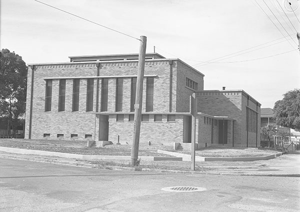
2. Substation No. 12 – 416 Kingsford Smith Drive, Hamilton
Substation No. 12, the first of its type to be built in Brisbane, included the combined functions of electricity substation, tramway substation and, interestingly, public toilets. Its construction was part of the post-war expansion of Brisbane’s transport infrastructure that also included Brisbane City Council orders for 30 electric trams in 1947-1948. The trams were scheduled to start arriving in 1949, so it was critical for the city to have larger substations to cope with the increased electricity demands.
Read more
Read more
Built in 1947, Substation No.12 was designed by Frank Costello who served as Brisbane’s City Architect from 1941–1952. Costello, influenced by Dutch modernist architect Willem Dudok, is credited with providing Council with a new modern classicism architectural style. His work is reflected in other substations throughout the city: Mount Coot-tha Lookout, Eagle Farm Pumping Station and substation, Second World War air raid shelters, and the Mount Crosby Filtration Plant.
Although it was a more efficient use of the site, the dual usage of both electricity and tramway substations within one building was unusual. Even more so was the inclusion of public toilets. The commercial and industrial areas of Hamilton were bustling with traffic, trams and people, so the public toilets provided a much-needed service to this area. The substation did; however, cause some concern for residents, who complained that it would interfere with their reception of radio programs.
For more information about this Local heritage place, visit Local Heritage Places online.
Note: Please do not enter. This is a privately owned facility and is not open to the public.
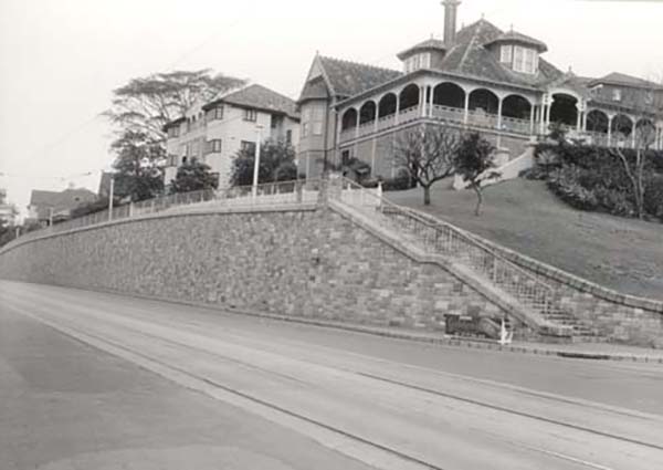
3. The Hamilton retaining walls – Kingsford Smith Drive
Built in the 1940s and 1950s as part of the widening of Kingsford Smith Drive, the 2 Hamilton retaining walls are landmarks and beautiful examples of the use of the local stone, Brisbane Tuff, with its distinctive pinks, greens and browns.
Read more
Read more
Kingsford Smith Drive was formerly known as Hamilton Road, and in 1953 was renamed in honour of Sir Charles Kingsford Smith, a Brisbane-born aviation pioneer who piloted the first transpacific flight and the first flight between Australia and New Zealand.
The Hamilton Retaining Wall No. 1 runs for 120 m along Kingsford Smith Drive from Riverview Terrace to Quarry Street. The Hamilton Retaining Wall No. 2 runs for approximately 200 m west along Kingsford Smith Drive from Crescent Road.
For more information about this Local heritage place, visit Local Heritage Places online.
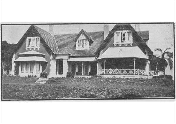
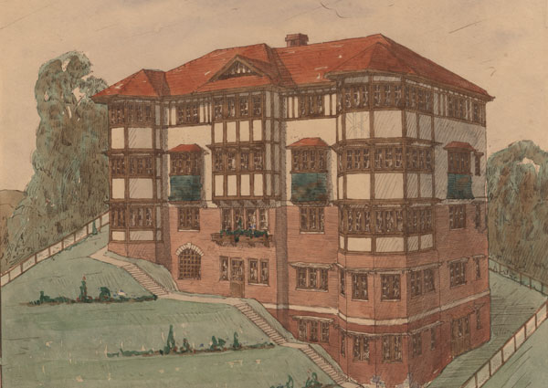
4. Hamilton Villas – Hamilton
From the earliest years of free settlement, the area around what is now Hamilton was considered one of Brisbane's most beautiful locations. Large attractive residences, collectively referred to as the Hamilton Villas, were built on the elevated land overlooking the Brisbane River. Hamilton became known as part of Brisbane’s ‘dress circle’ and a desirable address for Brisbane’s elite and working professionals. In their heyday, the Hamilton Villas were a place for glittering parties attended by important guests.
Read more
Read more
Hamilton was close to recreational attractions including the Hamilton Hotel and the racecourse, and the city via Hamilton Road (later renamed Kingsford Smith Drive) and the Breakfast Creek Bridge. The suburb’s population almost doubled between 1911 and 1921.
Notable Hamilton villas that can still be seen today include:
Blair Lodge – 242 Kingsford Smith Drive, constructed c. 1907 on Kingsford Smith Drive for the Munro family and designed by prominent Brisbane architect Claude Chambers. The design features an eye-catching gabled terracotta tiled roof, projecting dormers and high chimneys.
Cremorne – 34 Mullens Street, a substantial single storey high-set timber residence erected c. 1905–1906 on Mullens Street for Brisbane publican James Denis O'Connor. It is a striking design with a complex of hips, gables, ridges and pavilions, decorative gablets and finials, and 3 brick chimney stacks.
Euralla – 1 Eldernell Terrace, a masonry and tile house built in 1931 in a Dutch Colonial style by architectural firm Powell and Rae as the home of master builder George A. Stronach.
Eldernell – 39 Eldernell Terrace, a mid-Victorian stone residence built in 1869 for William Hemmant, a partner in the Drapery firm Stewart and Hemmant and designed by the prominent Brisbane architect James Cowlishaw. The house was renamed Bishopsbourne in 1964 when it became the new home of the Anglican Archbishop of Brisbane, Phillip Strong.
Greystaines – 240 Kingsford Smith Drive, a 3-storey block of flats erected in 1934 for Sydney James Dove and his wife Audree Thomasina Dove. It was designed by George Rae, a Brisbane-based architect who designed some of Brisbane's best interwar flats.
Lindenoa – 70 Hillside Crescent, a timber home built in 1908 in the Federation style for successful contractor, Justine Carr.
Lochiel – 6 Hillside Crescent, a substantial timber and masonry residence on the lower reaches of Toorak Hill and believed to have originated as a 2-storey masonry house erected by J. F. Buckland in the 1860s. After being purchased by John Samuel Cameron (the younger), additions to the house were made in 1899, 1906 and 1927. The house features distinctive timber detailing.
Marie Ville – 16 Hillside Crescent, a Victorian villa designed by Brisbane architects, John Hall & Son c. 1887 for Kate Quinlan, a partner in the firm Fitzgerald, Quinlan & Co. that established the Castlemaine Brewery at Milton in 1877–78.
For more information about this Local heritage place, visit Local Heritage Places online.
Note: Please do not enter. These are privately owned residences and are not open to the public.
Listen to related historical narrations
Listen to related historical narrations
The Courier-Mail (November 1934) reports on Greystaines, the new Mediterranean-inspired flats at Hamilton.
‘The Women's World’ – tea parties and card games.
Looking for more?
Looking for more?
Disembark the CityCat at Bretts Wharf ferry terminal to link with the Ascot and Hamilton Heritage Trail. Starting at Bretts Wharf, the 3.5 km trail takes you on a journey through sites and event that shaped Ascot and Hamilton’s history, including the establishment of the racecourse, Second World War activity in the area, and the suburbs’ stunning mansions.
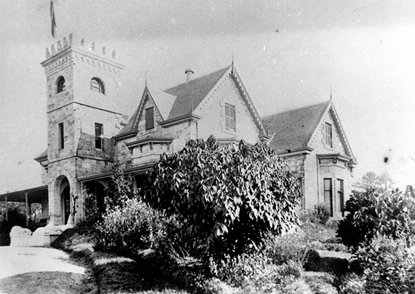
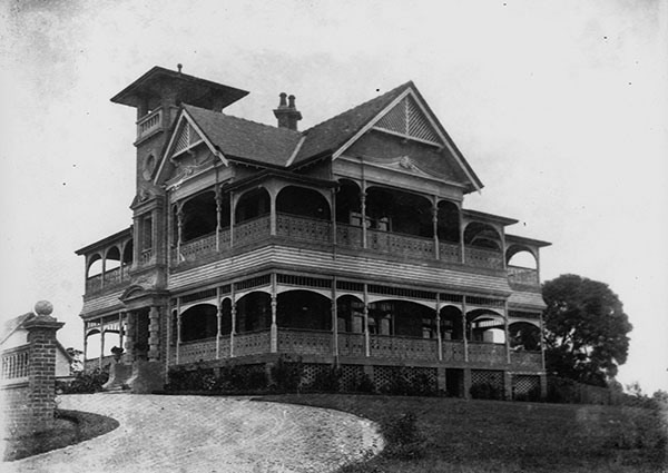
5. Toorak House – 28 Annie Street, Hamilton
Toorak House, the Gothic-influenced, castle-like residence on Hamilton Hill was built in c. 1865. Originally built for the former Premier of Queensland, Sir James Robert Dickson, Toorak House has been associated with some of the most important political and social figures of the 19th and 20th Centuries, including grazier George Moffatt (1916), John Gibson of the pioneer sugar family (1929), Brisbane businessman Patrick Woulfe, prominent grazier (c. 1930s), philanthropist and art collector Harold de Vahl Rubin (c. 1950), and pastoralist Sir William Allen (1963).
Read more
Read more
Toorak House, reputedly built from sandstone from the nearby Petrie quarries at Albion, was originally a single storey residence with a grand 2-level entrance tower extending through the verandah roof. The design of the residence shows the influence of the English Picturesque movement on Australian domestic architecture in the late 19th Century. Photographs of the residence show that the second storey and an upper section to the tower were added by the 1890s.
For more information about this State heritage place, visit the Queensland Heritage Register.
Note: Please do not enter. This is a privately owned residence and is not open to the public.
Listen to related historical narration
Listen to related historical narration
Toorak House sale, as reported in The Courier-Mail, 1950.
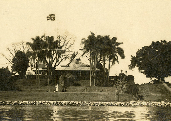
6. Newstead House – 199 Breakfast Creek Road, Newstead
Read more
Read more
Constructed in 1846, Newstead House is one of the only surviving examples of an 1840s Queensland colonial residence. At its heart is the original 1846 house built for Patrick Leslie, a grazier and explorer.
After the closure of Queensland as a penal settlement, Brisbane town was surveyed and lots were offered for sale from 1842. Leslie was one of the first to purchase property, and upon its completion in 1846, he moved into Newstead House with his family.
Constructed from brick, stone and timber, the original 2-storey house had living rooms and bedrooms on the upper floor and servants' rooms, cellars and kitchen on the lower floor. Leslie made the most of the house site with a 2.4 m wide verandah on the first floor facing the best views of the river.
In 1847, Newstead House was sold to Leslie’s brother-in-law Captain John Clements Wickham, whose name has been given to Brisbane streets, parks and terraces. Wickham made significant alterations and additions to the house. In 1853 he was appointed Government Resident of Moreton Bay, and the house became the unofficial government residence.
In 1921, Brisbane City Council bought the property and it was modified to suit new uses. The earliest parts of the house were conserved and refurbished. It is now a museum, and the landmark building is open for everyone to enjoy for recreational purposes, weddings and social events.
For more information about this State heritage place, visit the Queensland Heritage Register.
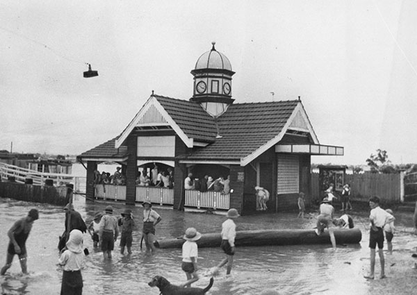
7. Bulimba ferry terminal – Road Reserve, Oxford Street, Bulimba
The Bulimba ferry terminal with its quaint design, terracotta roof tiles and delightful clocktower, speaks of a time in Brisbane when ferries were of paramount importance, before a network of bridges was developed, and before many people owned cars.
Read more
Read more
Designed by prominent architectural firm G.H.M. Addison and Son, it was built in 1922 by Ernest Taylor in response to the needs of waiting passengers, many of whom used the ferry to travel to and from work. On hot summer days in the late 1920s, the ferry house served an unforeseen purpose as a dressing shed and general headquarters for the youth of the district who found the water near the ferry house a splendid swimming pool.
Ferries have played a major role in Brisbane’s development since the early days of convict settlement. With the city developed around the twists and turns of the river, it was necessary to have reliable cross-river access. The first ferry service commenced between Customs House and Kangaroo Point in 1844, and by 1850, Samuel and Matthew Buckley operated a rowing boat ferry service from Bulimba. Ferry services continued to improve from the Bulimba terminal and by 1921, under the management of Balmoral Shire Council, it was decided to replace the old waiting shed at Bulimba with something more fitting.
The choice of such a noted architectural firm shows how important the ferry was to the community. The proposed design of the Bulimba ferry terminal, one of the largest ever built, was featured in the Architectural and Building Journal of Queensland. in December 1922. Arched openings, a gabled roof, decorative timberwork and the octagonal clocktower topped by a metal cupola created a picturesque riverside terminal that is now rare along the Brisbane River.
For more information about this State heritage place, visit the Queensland Heritage Register.
Listen to related historical narration
Listen to related historical narration
Recollections of Brisbane ferries.
Looking for more?
Looking for more?
Disembark the CityCat at the Bulimba ferry terminal to link with the Bulimba Heritage Trail. Starting at the Bulimba ferry terminal, the trail takes you to buildings and monuments that have shaped the local area. Information on air raid threats during the Second World War and details on the famous Goannary are some of the highlights.
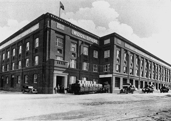
8. Brisbane Woolstores – Teneriffe
The row of imposing woolstores along the Brisbane River at Teneriffe were built to serve a thriving wool export industry. Wharves and railway sidings serving the booming riverside industrial area were used for quick and efficient goods transporting. The wool industry was so successful that it dominated riverside land at Teneriffe with multiple distinctive woolstore buildings constructed between 1909 and the 1950s.
Read more
Read more
One description of the proposed Goldsbrough Mort Woolstore, which appeared in the Brisbane Courier in 1913 explained that when erected, the commodious warehouse would afford unsurpassed railway and road facilities for the receipt and export of wool. The general process was that raw wool was railed to the woolstores and stored until it was sold, typically to purchasers overseas. When sold, the wool would be pressed, baled and trolleyed onto the wharves for export.
During the Second World War, owing to the proximity for shipping and wartime manufacturing, the location and facilities of the woolstores and wharves become part of the wider Brisbane war effort. A base for servicing the US submarines was established at the Brisbane Stevedoring & Wool Dumping Co. Ltd woolstores.
With the decline of the riverside industry at Teneriffe and the closing of the railway siding in 1990, interest in the industrial area and woolstore buildings for other uses began to increase. The former Queensland Primary Producers Woolstore was one of the first woolstore buildings to be converted into residential apartments as part of the renewal and revitalisation of the Teneriffe area in the mid-1990s.
Follow the links for more information about these local and state heritage places:
- Queensland Primary Producers No. 4 Woolstore (Commercial House)
- Mactaggarts Woolstore
- Australian Mercantile Land & Finance Woolstores
- Goldsbrough Mort Woolstore
- Elder Smith Woolstore
- Australian Estates No. 1 Store
- Australian Estates No. 2 Store
For more information about these and other sites, visit Local Heritage Places online.
Listen to related historical narration
Listen to related historical narration
The Rockhampton Evening News reports on the "new season wool clip" in September 1930.
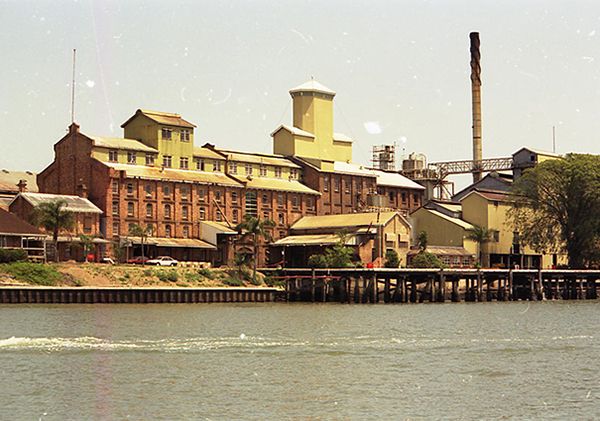
9. CSR Refinery (former) – Lamington Street, New Farm
The substantial Colonial Sugar Refining Company (CSR) Refinery was built in 1892–93 and seen at the time as a sign of an optimistic future for the Queensland sugar industry. This optimism at a time of economic depression was also the catalyst for the major industrial and warehousing development along the river at Bulimba.
Read more
Read more
The Colonial Sugar Refining Company was at the forefront of major changes in the sugar industry in the mid-to-late-19th Century, with technological developments in the refining process leading to a large increase in sugar consumption. The company concentrated its efforts on milling and refining sugar, establishing the Brisbane refinery as the fourth in its chain of refineries in other capital cities. The refinery on the Brisbane River gave it an important strategic position close to the city and the wharf, which allowed for large ships to dock.
The refinery was designed by James Muir, who had designed all the other sugar refineries in Australia, and construction was supervised by local architects John Hall & Sons. The complex included the refinery building with its char house, cistern, pan, melt and boiler houses, raw and refined sugar stores, workshop, a 2-storey building with offices, laboratory, and hessian rooms for sack manufacture, and the wharf.
Like many other industrial buildings along the riverside in New Farm and Teneriffe, the CSR Refinery is now residential apartments.
For more information about this State heritage place, visit the Queensland Heritage Register.
Note: Please do not enter. This is a privately owned property and is not open to the public.
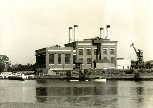
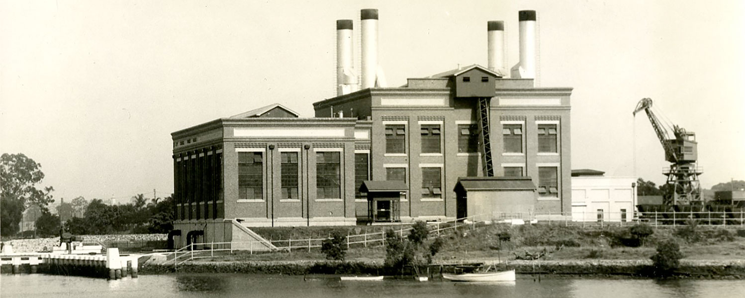
10. New Farm Powerhouse – 133 Lamington Street, New Farm
Described at its opening in 1928 as a grand institution, the New Farm Powerhouse heralded a new and important epoch in Brisbane’s industrial development. Despite critics objecting to the powerhouse as a wasteful, extravagant dream, it supplied people with light and power at the lowest possible price – the importance of which we can still relate to today.
Read more
Read more
The New Farm Powerhouse is an imposing and elegant Interwar Stripped Classical industrial brick structure. It was designed by the Council architect for the Tramways Department, Roy Rusden Ogg and built by G.H Turner, who won the construction job from a pool of 12 tenders. Beginning in January 1927, construction was completed in record time with pile driving for 800 ironbark piles. The first of 2 million bricks were laid in April 1927 and the first electrical current was sent in April 1928.
By its completion, the New Farm Powerhouse comprised 7,000 cubic yards of concrete (5,352 m3) and 500 tons (508 tonnes) of fabricated steel, as well as old tramway rails to reinforce walls and machinery pads.
Throughout the post-war years, the New Farm Powerhouse provided electricity for Brisbane’s tram network and the suburbs of Toowong, Ithaca and Yeerongpilly. After 1989, it was superseded by the Swanbank Power Station and became largely redundant until Brisbane City Council commenced construction in 1999 to convert the building into a cultural and performing arts venue under the direction of its Urban Renewal Task Force. This conversion proved to be a successful example of adaptive reuse of a heritage building.
For more information about this Local heritage place, visit Local Heritage Places online.
Listen to related historical narration
Listen to related historical narration
Announcing the opening of the New Farm Powerhouse, The Telegraph, 28 June 1928.
11. Canning Bridge and Reserve – 186 Lytton Road, East Brisbane
Hailed as the first major bridge built in Brisbane since the construction of the Story Bridge, the Canning Bridge was originally known as the Norman Creek Bridge. It was part of Brisbane City Council’s £10,000,000 ($18,933,041) post-war works program and connected East Brisbane to Norman Park and the suburbs beyond.
Read more
Read more
Described in 1954 as an imposing concrete structure, the bridge is an attractive example of the work produced by R. J. Drysdale, who at the time was an assistant to Hylton B. Dale, architect for the City of Brisbane. M. R. Hornibrook, whose company constructed the Story Bridge and Hornibrook Highway Bridge, won the tender for the construction of the Norman Creek Bridge at a cost of £86,379 ($163,541). It was estimated to take 2 years to build, but limited Council finances extended the build to 3 years.
The deck was designed with arched concrete ribs running parallel with the roadway and rectangular piers set at angles across the ribs to reflect the angle at which Norman Creek enters the Brisbane River. The 2 centre piers extend beyond the outermost arches, tapering and stepping outwards to form bracket-like supports to the edge of the road deck. Originally, the deck carried central tram tracks with a vehicle lane and pedestrian path on each side. However, after the tramway system was decommissioned in 1969, the deck was altered to 2 vehicle lanes in each direction.
In late 1956 the bridge was renamed for Francis Joseph Canning, who served as president of the Council of Progress Associations in Brisbane for 20 years.
For more information about this Local heritage place, visit Local Heritage Places online.
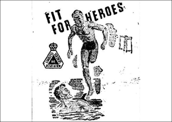
12. Limbless Soldiers’ Bowling Club (former) – 60 Oxlade Drive, New Farm
In 1946, Brisbane City Council offered the Limbless Soldiers’ Association a site for a new club house in New Farm. Previously used during the Second World War as a US naval officers’ club, the facility boasted a dance hall, stage, film projectors, lounges, bar, kitchen and boat deck.
Read more
Read more
The club was officially opened in 1949 by the Queensland branch of the Returned Limbless Sailors and Soldiers Association (RLSSA). In the same year, Queensland bowlers donated £4,000 ($7,572) for a fully equipped green and its upkeep paid for 2 years.
Plans for the club began several years earlier in 1944 with the association announcing that it hoped to secure a property where a swimming pool, full-sized bowling green and a tennis court could be provided. In 1945, the association launched a '£35,000 Appeal’ for the Limbless Soldiers’ Patriotic Appeal Fund, publishing that it “has pledged itself to safeguard the interests of all servicemen who have lost a limb...” and do all they could “in order that these men, who have sacrificed so much will receive the consideration due to them”. Slides announcing the appeal and asking for donations showed at the Mayfair Theatre in Sandgate, and the campaign raised its target £35,000 ($66,252) between 1944 to 1946.
The Limbless Soldiers’ Bowling Club was later renamed the Merthyr Bowls Club. In 1978 the lease was transferred from the RLSSA to the Returned Services League of Australia (RSL), which leases the land from Council, and still subleases facilities to the bowls club.
For more information about this Local heritage place, visit Local Heritage Places online.
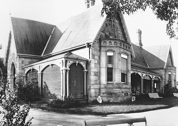
13. Shafston House – 23 Castlebar Street, Kangaroo Point
In 1876, Shafston House was described as a brick and stone house with a roof of hardwood shingles and iron, and comprising a drawing room, dining room, 5 bedrooms, closets, dressing and bathrooms, kitchen and about 6 servants' apartments, a large brick stable with 2 stalls, coach house, man's room and hay house. It is the third oldest house in Brisbane.
Read more
Read more
Shafston House reportedly began as a single storeyed house known as Ravenscott, constructed by the Reverend Robert Creyke in the early 1850s on the stunning Brisbane River frontage at Kangaroo Point. In 1852, pastoralist and politician Henry Stuart Russell acquired the property along with several neighbouring blocks, and completed the house, naming it Shafston.
Some remodelling of the house carried out in the 1880s included replacing the verandahs to the present form, adding the entry portico and likely the bay windows, and more elaborate and picturesque Gothic detailing. The architect for this work is thought to be former Queensland Colonial Architect, Francis Drummond Greville Stanley.
Shafston House was acquired by the Commonwealth Government of Australia in 1919 and extensive alterations undertaken to convert it into the Shafston House Anzac Hostel for the care and treatment of First World War ex-servicemen. When the Prince of Wales (later, King Edward VIII) visited the facility in 1920, The Telegraph newspaper noted that the government’s Repatriation Department did well to secure Shafston House, with its expansive views of the beautiful river.
From 1969, the Royal Australian Air Force (RAAF) occupied Shafston House, described in the RAAF News as, “a gracious edifice redolent of the elegance of an earlier era.” It ended its lease with a flag lowering ceremony held on the Ides of March (15 March), 1988, and the property was sold to a private buyer.
For more information about this State heritage place, visit the Queensland Heritage Register.
Note: Please do not enter. This is a privately owned residence and is not open to the public.
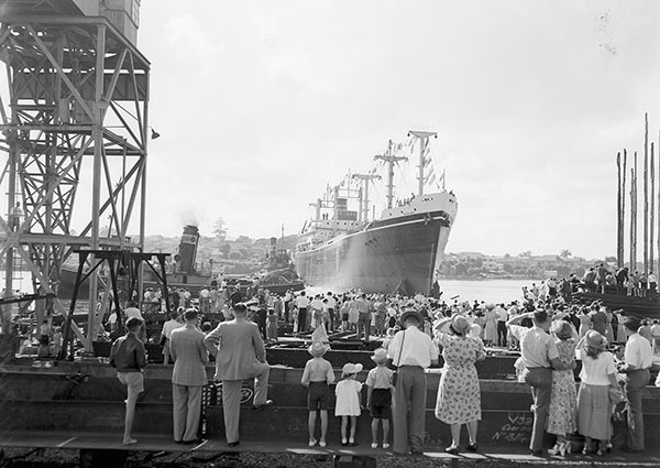
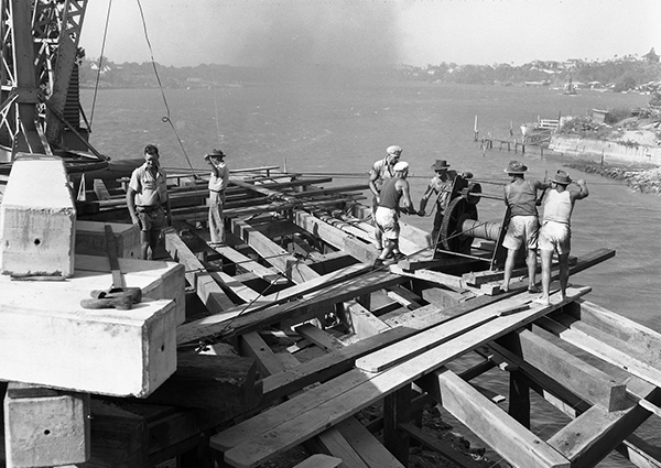
14. Evans Deakin Dry Dock – 78 Cairns Street, Kangaroo Point
The original dry dock was built for shipwright Hugh Moar in 1884. In 1940 with Brisbane’s role in the Second World War increasing, the Queensland Government Department of Harbours and Marine acquired the dry dock to build berths for 2 naval vessels that each weighed 9,000 tons (9,144 tonnes). This required excavating 35,410 cubic yards (27,072 m3) of mostly rock to enlarge the dock.
Read more
Read more
By 1944, a new 600 ft (182 m) wharf was constructed to fit out new ships and the site was leased to engineering firm, Evans Deakin & Co Ltd, which undertook Brisbane’s major shipbuilding projects during the Second World War. The company was particularly successful and The Courier-Mail newspaper in 1944 reported it as having made another splendid contribution to the war effort when it completed repairs to an American submarine. Arthur Joseph Deakin, engineer and co-founder of Evans Deakin & Co Ltd, described the repairs as, “a very ticklish job and not many people in Australia would have attempted it.”
Evans Deakin & Co Ltd built many warships for the war effort including its first corvette, a small and fast vessel in a naval class below a frigate. It built the HMAS Lismore in 1940; corvettes Launceston, Ipswich and Broome completed in 1941; corvettes Bunbury, Bundaberg, Gympie, Townsville and Fremantle completed in 1942; corvettes Ararat, Parkes and Kiama were launched in 1943, and in 1944 the frigate HMAS Murchison, the last and largest warship to be constructed at the dry dock, was underway. After the Second World War, Evans Deakin & Co Ltd, produced cargo vessels including the River Burdekin, River Norman, Dalby, River Burnett and Dulverton. Evans Deakin & Co Ltd became Evans Deakin Industries Ltd in 1960. In March 2001, it merged with Downer & Co to become Downer.
Following its closure, the dry dock was redeveloped for use as a marina associated with Brisbane’s Dockside Apartments complex.
For more information about this Local heritage place, visit Local Heritage Places online.
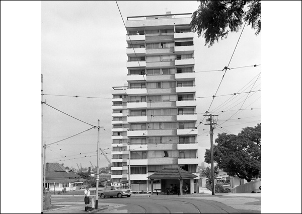
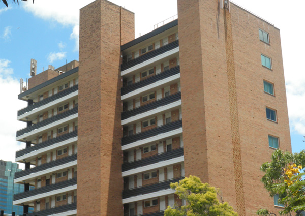
15. Gleneagles – 79 Moray Street, New Farm
Winner of the 1965 Queensland Chapter of the Royal Australian Institute of Architects (RAIA) Building of the Year Award, Gleneagles was a pioneering project of its time for aged accommodation in Queensland.
Read more
Read more
Set close to the city with a riverside aspect, Gleneagles is a prominent example of innovation in aged accommodation. It was designed by Curro, Nutter and Charlto, engineered by R. J. McWilliam and Partners and built by T. J. Watkins Ltd for the Royal Antediluvian Order of Buffaloes. The order was a friendly society that recognised the need to accommodate aged people and provided members with practical assistance by establishing facilities such as retirement homes.
The complex comprises 2 high-rise towers. At the time, these were the 13-storey Falcon House with 44 double units and a matron’s unit and office, and the 16-storey Peregrine House with 53 units and a Commonwealth Bank of Australia Savings Bank branch. Linked by a single-storey recreation building, both houses encouraged community interactions through communal roof terraces, large gardens and lounges at ground level.
Gleneagles was built at a time when developers were considering the need for higher-density housing in Brisbane and with river views highly prized, high-rise residential developments near the river were increasing. The vision of Rowley Pym, a former Western Queensland fencing contractor turned developer and real estate broker, it changed the character of New Farm and housing trends for aged accommodation. Pym’s contribution to the Brisbane urban landscape also included Torbreck, the first high-rise, mixed-use development in Queensland.
For more information about this Local heritage place, search Local Heritage Places online.
Note: Please do not enter. This is a privately owned residence and is not open to the public.
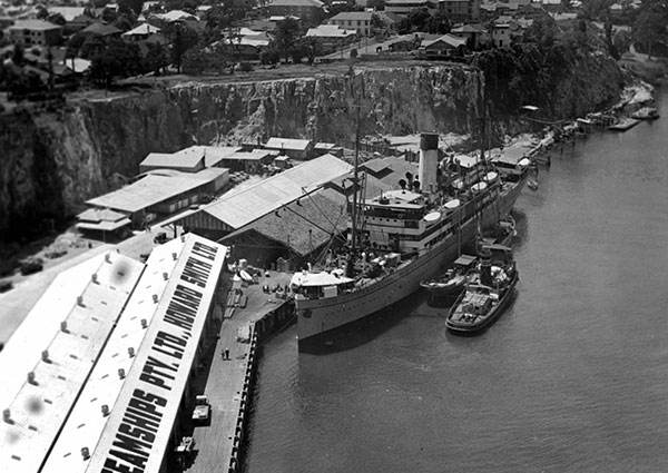
16. Howard Smith Wharves – 5 Boundary Street, Brisbane
In a bid to save money, the Howard Smith Wharves were constructed between 1934 and the early 1940s in conjunction with the Story Bridge. The projects were a Queensland Government initiative to provide relief work during depression years in the 1930s, but also to provide critically important infrastructure for the city.
Read more
Read more
Initially known as the Brisbane Central Wharves, these were leased by the Australian coastal shipping company Howard Smith Co. Ltd and became known as the Howard Smith Wharves from the mid-1930s. At its peak, the company was one of the largest and most successful shipping enterprises in the Port of Brisbane.
In the Second World War, Brisbane was the United States’ largest naval base in Australia and civilian safety was addressed with an air raid shelter construction program. With no shelters, the Waterside Workers’ Federation called for air raid shelters on the wharves, noting that wharf workers were doing their best for the war effort and should be afforded some protection.
Brisbane City Council built five air raid shelters for the Bureau of Industry (a Queensland Government agency) between 1941 and 1942 near the Howard Smith Wharves, as there was a substantial workforce there and the Story Bridge was seen as a prime target in wartime. Of the 5 shelters, 3 were 'pillbox' types built at many places throughout Brisbane. The other 2 types of shelters were constructed of large stormwater pipes, an unusual air-raid construction style for Council at the time.
In 2009, an adaptive re-use development was proposed for the wharves, comprising 3 distinct precincts: a hotel and tourist precinct; a restaurant, commercial and entertainment precinct, and an outdoor recreational zone boasting community facilities to cater for local residents. The redeveloped Howard Smith Wharves site was opened in late 2018 and has become a popular riverside precinct.
For more information about this State heritage place, visit the Queensland Heritage Register.
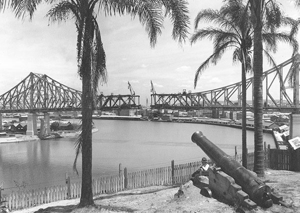
17. Story Bridge – Bradfield Highway, Kangaroo Point
Designed to harmonise with Brisbane's natural skyline, the Story Bridge is the largest span metal truss bridge designed and built mostly by Australians from materials manufactured in Australia. Approximately 12,000 ton (12,192 tonne) of steelwork was manufactured in the Evans Deakin & Co Ltd workshop for the bridge construction, undertaken as a relief work scheme by Evans Deakin-Hornibrook for the Queensland Government.
Read more
Read more
Dr J. C. C. Bradfield, designer of the Sydney Harbour Bridge, was appointed consulting engineer in January 1934 and James A. Holt as supervising engineer for the bridge design and contract supervision. The bridge was named for John Douglas Story who was the Public Service Commissioner and a member of the Bridge Board. He was also influential in the development of the University of Queensland, and was the first full-time Vice-Chancellor, serving in an honorary capacity from 1938 to 1959.
Construction of the Story Bridge was a technical achievement, built from both sides of the river simultaneously. Excavations for the southern pier required men to work in watertight airlock chambers within steel caissons up to 40 m below ground level. This was the deepest airlock work done in Australia at the time and, at the completion of the bridge, the airlock was given to the University of Queensland to be used for experimental purposes.
The Story Bridge is 1,072 m long and has the largest spanning metal truss in Australia at 281.7 m. It required 1.25 million rivets and more than 30,000 L of zinc paint. Over the course of construction, 450 men had been employed and there were 3 fatal accidents.
While the Story Bridge was seen as premature in terms of traffic needs, it proved to be an important piece of the city’s infrastructure when American troops arrived during the Second World War in 1942. The bridge is now an integral part of the Brisbane River landscape and an iconic city landmark.
For more information about this State heritage place, visit the Queensland Heritage Register.
Listen to related historical narration
Listen to related historical narration
The making of the Story Bridge.
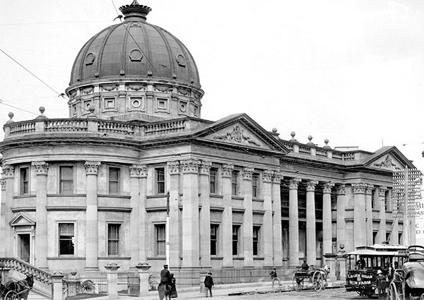
18. Brisbane Customs House – 427 Queen Street, Brisbane
The 1880s was a period of economic prosperity for Brisbane and, when completed, the new Customs House was amongst the more impressive of grand public and commercial buildings being erected at this time. It is a 2-storey rendered brick building on stone foundations. It is an example of Classical style and incorporates pedimented gables, copper dome and a massive colonnade. Heraldic shields flanked by a kangaroo and an emu and the words “Advance Australia” adorn the pediments. These icons were precursors to the official Queensland Coat of Arms that was not granted by Queen Victoria until 1893.
Read more
Read more
The Customs House was needed for Brisbane when Moreton Bay was declared a port of entry for commercial shipping and immigration in 1846. The first small wooden customs house was built in 1850, with the site selected for its proximity to commercial activities on the South Brisbane Reach.
However, expansion of the colony and Brisbane’s importance as a major shipping centre meant the Port of Brisbane quickly outgrew the early customs house, which was soon unable to cope with the volume and quantity of goods passing through.
The existing Customs House was erected between 1886 and 1889 to a design prepared by Charles McLay, the major designer under George Connolly of the Queensland Colonial Architect's Office.
John Petrie & Son, one of Brisbane's oldest and most respected building contractors tendered a price of £37,342 (equivalent to $6.5 million today). Difficulties with the supply of some materials, especially stone for the foundations, as well as alterations to the original plans delayed the anticipated completion, and the building was opened on 2 September 1889. Its river-facing court is supported by beautiful Brisbane Tuff stone retaining walls, with wrought iron balustrade and a wide staircase leading down to the waterfront. Much of the stone for construction came from the quarry across the river at Kangaroo Point Cliffs.
With Australia’s Federation, the Brisbane Customs House was transferred to the Commonwealth by 1908, and since that time has undergone several refurbishments, including in 1950 when it reopened after a 2-and-a-half-year major renovation. In the mid-1980s, the Australian Customs Department moved out of the building to Australia House. The building remained vacant from 1988 until leased by the University of Queensland and restored as a convention centre and art gallery in the mid-1990s.
For more information about this State heritage place, visit the Queensland Heritage Register.
Listen to related historical narration
Listen to related historical narration
The 1926 retirement of Captain A. A. Wardle and his recollections as reported in the Brisbane Courier.
Looking for more?
Looking for more?
Disembark the CityCat at the Riverside ferry terminal to link with the Reflections on the River Heritage Trail. With 29 points of interest, the trail winds along the Central Business District riverfront and celebrates Brisbane River’s role in our city's history.
19. Brisbane Travelodge (former) – 355 Main Street, Kangaroo Point
The Brisbane Travelodge brought with it a new way to holiday for working families wanting to take an affordable break. Each unit boasted its own self-contained bathroom, which meant the days of several families sharing one washroom and toilet were a thing of the past.
Read more
Read more
Once the largest motel in Queensland, the Brisbane Travelodge was originally built as a small single-storey motel, but by 1961 had opened as a modern 5-storey building with 40 rooms and an iconic zigzag roofline. It is likely that the building was designed by T. H. O’Connor Pty Ltd.
The Brisbane Travelodge was revolutionary in its approach to motel holiday accommodation with luxuries such as individual kitchenettes, a generous car park for guests, a pool, verandahs for river views, and a rooftop restaurant.
Its design marked the shift in Australian tourism away from more traditional holiday and guest houses towards self-contained, individual amenities. The Postwar Modernist style also heralded the transition towards higher-density accommodation and the use of more private spaces, such as balconies and sundecks. The success of this accommodation type is reflected in the continued expansion of the Travelodge, which in 1968 added a further 51 rooms to the complex.
The Brisbane Travelodge is now individually owned units.
For more information about this Local heritage place, visit Local Heritage Places online.
Note: Please do not enter. This is a privately owned residence and is not open to the public.
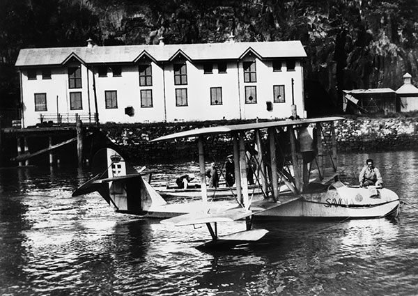
20. Naval Stores (former) – 34 Amesbury Street, Kangaroo Point
The former Naval Stores comprise a pair of 2-storey iron-clad, stud-framed buildings and a wharf. Constructed between 1886 and 1888, the buildings have been used for more than 130 years as a military storage depot and for training. The Naval Stores were built at a time of heightened tension between Great Britain and the Russian Empire, and consequent fears of a Russian invasion of Queensland.
Read more
Read more
In 1884, the Colony of Queensland commissioned the Gayundah and Paluma gunboats. In 1885, the gunboats arrived from Newcastle-on-Tyne, England, and with the acquisition of other vessels, a naval depot for storage, repairs and training became necessary. The government established the Naval Stores on the site of a former Kangaroo Point quarry and trained a naval force of several hundred officers and crew, mainly part-time volunteers.
Store No. 1 contained a ground floor battery and lecture rooms used for training. Its first floor originally had 4 rooms used for stores and carpenters' shops. Store No. 2 originally consisted of 2 large rooms on each floor. Workshops were on the ground floor and its torpedo storeroom was on the first floor. Since then, various modifications to this layout have occurred.
This Kangaroo Point depot was the base of the Queensland Navy until the formation of the Royal Australian Navy (RAN) after Federation, and Australia had become a nation. As the Queensland Naval Brigade developed, depots were also built at Maryborough, Rockhampton, Townsville, Cairns and Cooktown.
In 1903, the Naval Stores became part of radio communication history after receiving signals from the Gayundah, the first Australian ship to use wireless telegraphy. The Naval Reserves occupied the site through the Second World War and vacated in 1959, when the Australian Army took over until 1984.
In 1987, Brisbane City Council purchased the property.
For more information about this State heritage place, visit the Queensland Heritage Register.
Listen to related historical narration
Listen to related historical narration
A description of training exercises at the Naval Stores.
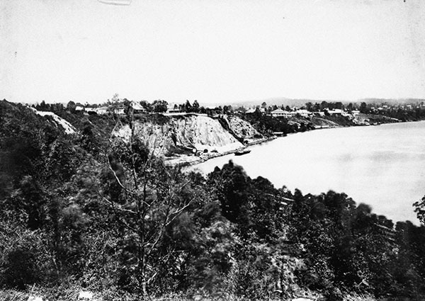
21. Kangaroo Point Cliffs – 77 Lower River Terrace, Kangaroo Point
Kangaroo Point Cliffs was originally a prominent rocky ridge where, around 1826, Commandant of Moreton Bay penal settlement Captain Patrick Logan opened a quarry to supply local volcanic stone, Brisbane Tuff, for building the Moreton Bay Penal Settlement that shifted from Redcliffe to North Brisbane the previous year. Located near the later Naval Stores, the quarry punted stone across the river for construction of government buildings, including the Commissariat Store (1828–29) and its retaining wall on William Street. At the northern end of Kangaroo Point, river flats were cleared and planted with wheat and maize to supply food for the new settlement.
Read more
Read more
After the penal colony was closed, Kangaroo Point was surveyed into allotments and became Brisbane’s first suburb in 1842. The lower areas once used for farmland attracted various early industries, including a boiling down works, a soap and candle factory, ship building, foundries and sawmills.
From 1842, the Kangaroo Point quarry was rented to private builders, including John Petrie, until 1860 when it was placed under control of the newly established (September 1859) Brisbane Municipal Council. The Council continued to sub-lease the quarry to private builders who mainly supplied stone ballast to ships. But during the 1880s the site was extensively developed for quarrying, railway and wharfage, including construction of new coal wharves at the southern end of the Kangaroo Point Cliffs, adjacent to the South Brisbane Dry Dock. The wharves facilitated the export of coal mined at Ipswich and railed to South Brisbane.
In 1886–88 as part of Queensland's marine defence strategy, the colonial government constructed a depot for the Queensland Marine Defence Force at the northern end of the Kangaroo Point Cliffs, on the floor of the early Kangaroo Point Quarry.
In 1898, the government’s Marine Department opened a new quarry south of the Naval Depot and about halfway along River Terrace, to supply rock for river walls at Hamilton. This was the start of a scheme of dredging and training walls undertaken by the Department of Harbours and Rivers (later the Department of Harbours and Marine) to complete development of the Brisbane River Port. Extensive quarrying by the Marine Department opened the rock face of the Kangaroo Point Cliffs between the Naval Stores at the northern end of the site and the coal wharves at the southern end, creating the dramatic cliff face seen today. By 1976, when control of the Brisbane River passed to the Port of Brisbane Authority, most of the available Brisbane Tuff from Kangaroo Point had been exploited and the quarry was closed.
The Kangaroo Point quarry floors and ridge are now important public park reserves, while its cliffs are popular for abseiling, rock climbing, and enjoying the views.
For more information about this State heritage place, visit the Queensland Heritage Register.
Listen to related historical narration
Listen to related historical narration
A gold find was reported by the Brisbane Courier, 17 May 1930.
22. Home – 9 Leopard Street, Kangaroo Point
Home is a grand 2-storey Federation era residence perched on the Kangaroo Point Cliffs high above the Brisbane River. It was designed by notable Brisbane architect Alexander Brown Wilson for John Lamb, co-proprietor of Edwards & Lamb. The red brick house erected in 1902–03 features Queen Anne-style ornate wraparound verandahs and a prominent observatory tower above its impressive entry.
Read more
Read more
The Queen Anne style brought more elaborate flourishes to the Federation era and was highly favoured by wealthy merchants and industrialists of the late 19th Century. John Lamb’s successful Edwards & Lamb drapery business traded in in several buildings at the top of Queen Street, Brisbane from c. 1881 until well into the mid-20th Century. Edwards & Lamb was a forerunner to Brisbane’s large department stores and introduced retail innovations such as a cash-and-carry system and mail order service for country customers. The firm supported workers’ rights by being active in a campaign for shorter working hours for retail employees. It also introduced a superannuation scheme and additional holidays around Christmas time.
Home, also known as Lamb House, remained in the Lamb family until 2021. New owners have undertaken major restorations to return the landmark residence to its former splendour.
The substantial face brick residence displays features typical of the Federation-era Queen Anne style, such as asymmetrical design, complex projecting gables with timber detailing, bay windows and highly decorated timber verandahs with cast iron balustrades. The 4-storey observatory tower is a landmark feature above an impressive portico entry with moulded concrete columns and pediment. The interior is also resplendent with pressed metal ceilings, ornate plasterwork, and detailed lead lighting that includes a laylight above a dramatic and stately red cedar staircase that is central to the arrangement of rooms.
For more information on this State heritage place, visit the Queensland Heritage Register.
Note: Please do not enter. This is a privately owned residence and is not open to the public.
23. Cliffside Apartments – 76 Lower River Terrace, Kangaroo Point
In 1937 the Cliffside Apartments, built on a sheer cliff of Brisbane Tuff, were described by The Courier-Mail as, “the newest, the best and the most attractive offering in Brisbane". The building is also an example of the independence and business acumen of Australian women in the interwar period (1919-1939), particularly Doris Regina Booth and her sister Selma Dore.
Read more
Read more
Doris was a successful mine manager and company director and, amongst other achievements, was appointed as the sole woman member of the first and second Legislative Council of Papua New Guinea in 1951–57. She was awarded an Order of the British Empire (OBE) for her humanitarian work in Papua New Guinea. When she undertook the Cliffside Apartments project, her sister, Selma, capably handled the design and construction process to completion.
Designed by architect and engineer R. Martin Wilson in the English Revival or Tudor Revival style, the Cliffside Apartments were touted as the most advanced flat design in Australia and represented the dramatic growth of apartment buildings in the years after the First World War.
The Cliffside Apartments is a 5-storey building of 8 flats with strong architectural accents, including striking hexagonal bay windows and prominent northern views to the river from its balconies. It also offered security and freedom for unmarried women and young couples, and showed Brisbane that flats and apartment living could be both comfortable and stylish.
For more information about this State heritage place, visit the Queensland Heritage Register.
Note: Please do not enter. This is a privately owned residence and is not open to the public.
24. South Brisbane Dry Dock – 412 Stanley Street, South Brisbane
The South Brisbane Dry Dock was designed in 1875 by William David Nisbet, chief engineer for the Colony of Queensland, Department of Harbours and Rivers, and constructed between 1876 and 1881. Until its closure in 1972, the dock served a major role in Queensland’s shipping industry and is one of the oldest surviving, substantially intact dry docks in Australia.
Read more
Read more
Shipping played a significant role in the development of Brisbane and Queensland during the 19th Century. Brisbane was declared a port of entry in 1846, a warehousing port in 1849, and Customs House was erected in 1850. Following Queensland’s separation from New South Wales in 1859, the economy boomed on the back of agriculture and gold discoveries and the number of ships passing through Brisbane surged. It had become a more accessible port after the Upper Flats near the river mouth were cleared in 1871, enabling large vessels to access the Town Reach.
The busy Brisbane port required a substantial facility for the maintenance, repair and refitting of commercial and government ships. A site for dry docking, or graving, was chosen on government-owned land between Stanley Street and the river at South Brisbane. Nisbet’s design comprised a 32 ft (9.75 m) high, 313 ft (95 m) long dock, with a possible extension to 450 ft (137 m). Ships would float into the dock where a caisson (dock gate) closed across the sill (or cill) at the entrance, and the dock would be pumped dry. Once the vessel was repaired, sluice gates in the dock opened to let in river water before the caisson opened, and the ship floated out.
The dock served as Queensland’s only graving dock until the mid-20th Century. It also served an interesting social function after 1902 as a venue for swimming carnivals when not being used for ships. During the Second World War the dry dock was used as a ship repair base for naval vessels. A United States Navy submarine base was also established at the dock in April 1942, necessitating additional wharfage and facilities. It was a vital piece of infrastructure during the Second World War, docking and repairing 298 American, Australian, British and French vessels.
In 1944, the substantial Cairncross Graving Dock opened downstream and catered for large vessels that the South Brisbane Dry Dock had previously been unable to dock. The South Brisbane Dry Dock became primarily a repair shop for Queensland government vessels, but changes in shipyard practices, the dominance of large bulk carriers, construction of the Captain Cook Bridge and the need for a major rehabilitation of the dock led to its closure in September 1972. The South Brisbane Dry Dock has operated as part of the Queensland Maritime Museum since 1979.
For more information about this State heritage place, visit the Queensland Heritage Register.
Note: the Queensland Maritime Museum is open to the public. Check their website for details.
25. Former Victoria Bridge Abutments – 2 Melbourne Street, Brisbane
The Victoria Bridge Abutments are remnants of the fourth bridge to cross the Brisbane River at this point. The first 3 bridges were either ruined by marine wood borers or swept away in floods. Having survived the elements of the Brisbane River, the fourth Victoria Bridge was demolished in 1969 to make way for the present Victoria Bridge.
Read more
Read more
Constructed in 1896 to a design by the Queensland Government Architect, A. B. Brady, Victoria Bridge was constructed of iron and arched abutments of distinctive Brisbane Tuff with neoclassical ornamentation at each end. It served as an important link between the north and south sides of Brisbane and spurred on development of the south bank.
The opening of Victoria Bridge may have been a shambolic affair with The Week newspaper reporting a wild rush by the assembled public for fragments of ribbon after it was cut. Opening ceremonies on both sides of the bridge required back and forth processions by dignitaries.
Until the 1930s, Victoria Bridge was the only permanent crossing between north and south Brisbane. With increased traffic demands, a second bridge would be needed and the Grey Street (William Jolly) Bridge was constructed in 1925, followed by the Walter Taylor Bridge in 1936.
In 1969, the Victoria Bridge was demolished but portions of the Brisbane Tuff abutments were left in place to show its earlier form.
For more information about this State heritage place, visit the Queensland Heritage Register.
Listen to related historical narration
Listen to related historical narration
In 1893, The Week reported that the Brisbane River flooded with devastating effect.
Looking for more?
Looking for more?
Disembark the CityCat at the Southbank ferry terminal to link with the Secrets of South Brisbane Heritage Trail. This trail highlights important historical sites, colourful stories and infamous events that shaped South Brisbane's history.
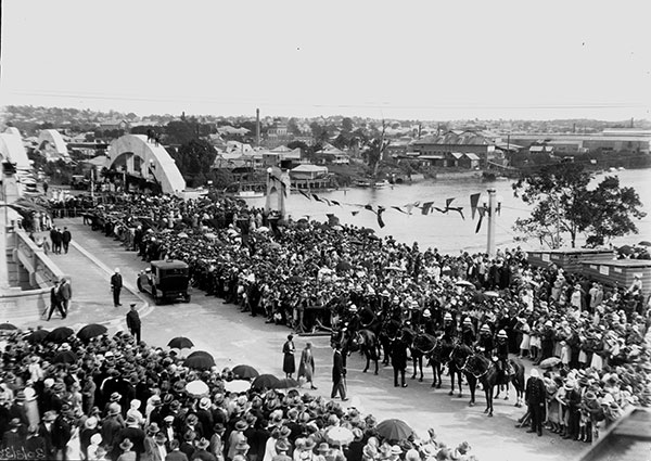
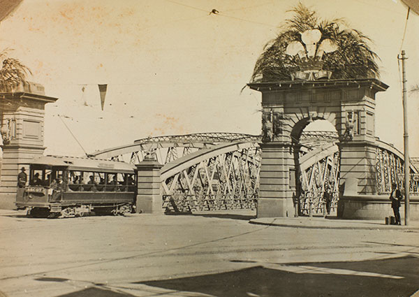
26. William Jolly Bridge – Between North Quay and Grey Street (near Stanley Place)
The William Jolly Bridge was originally known as the Grey Street Bridge. It was constructed following the formation of the greater City of Brisbane in 1925 and has 3 major spans and spectacular arched ribs rising through the deck. It was hailed at the time as 'the largest reinforced concrete bridge in the Southern Hemisphere and one of the largest in the world’. Evans Deakin & Co Ltd fabricated the steelwork that was encased in Gunite, a sprayed dry mix concrete and relatively new technology that would also be used later in construction of the Cairncross Graving Dock.
Read more
Read more
Designed by engineer Alison Eavis Harding Frew, the bridge was to be a Brisbane landmark. M.R. Hornibrook Ltd commenced bridge construction in August 1928 after its winning tender of £384,850, ($35,010,955); however, the total cost would eventually be substantially more at £674,526 ($61,363,648).
In The Telegraph, March 1930, Hornibrook noted that, “the bridge would rank next to the Sydney Harbour Bridge among Australian bridges. However, there was far more civil engineering involved in the Grey Street Bridge than in the Sydney bridge.
With such a lengthy construction timeframe and complex engineering, problems were inevitable. In July 1930, construction halted due to one of the most unusual fires in Brisbane history. The fire started 100 ft (30.48 m) below the Brisbane River surface in one of the bridge airlocks. While the workmen managed to quickly reach safety, it was several hours before the fire was extinguished.
The bridge was officially opened on 30 March 1932 by then Governor, Sir John Goodwin, 11 days after the opening of the Sydney Harbour Bridge. The grand opening was attended by a huge crowd and some people climbed the arches for a better view. For those who could not attend, the event was described over the radio on station 4QG.
For more information about this State heritage place, visit the Queensland Heritage Register.
Listen to related historical narration
Listen to related historical narration
"Unusual blaze" during construction of the bridge, reports the Queensland Times, 1930.
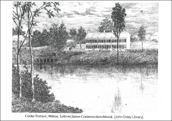
27. Cook Terrace – 249 Coronation Drive, Milton
Cook Terrace, also known as Milton Terrace or Gloralgar Flats, was constructed as a 2-storey row of 6 brick houses by Joseph Blain Cook. The Brisbane builder had purchased the land subdivisions 1–6 of Milton House Estate from squatter John Frederick McDougall. The architect is unknown, but the first house was erected in late 1888 and the row was completed in 1889.
Read more
Read more
The terraces were built as a single rental property because the Undue Subdivision of Land Prevention Act of 1885 prohibited the granting of individual titles for separate terrace houses. The Queensland Government introduced the legislation to prevent the crowded urban development seen in cities like Sydney and Melbourne.
The development reflected the economic optimism of the late 1880s, but within 2 years, Cook was declared insolvent and the terrace passed to his mortgagees. By 1895 the row was known as Milton Terrace. With its river views, breezes and proximity to the town centre, it mainly attracted professional and white-collar tenants and remained one of Brisbane's more prestigious rental addresses well into the 20th Century.
By 1920 each house had been subdivided into smaller flats and builder Simon Smith, who acquired the property in 1923, may have been responsible for removing the front parapet and installing dormer windows. In the 1930s the building became known as Gloralgar Flats.
It is believed that army authorities rented the flats as officer accommodation during the Second World War. After then, the verandahs were enclosed and the 6 houses were converted into 27 flats that were considered something of a bohemian retreat. Despite its decline, the building remained a visual landmark along Coronation Drive and in 1984 it was refurbished as offices and a restaurant.
For more information about this State heritage place, visit the Queensland Heritage Register.
Note: Please do not enter. This is a privately owned residence and is not open to the public.
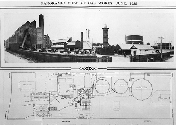
28. Gas Stripping Tower – Davies Park
The only one of its type in Australia, the Gas Stripping Tower is not quite in its original location. In fact, it is about 150 m from where it was first constructed. The latest in gas production technology at the time, the demountable cast iron tower was erected in 1912 at the South Brisbane Gas & Light Company (SBGLC) works site in Montague Road, West End.
Read more
Read more
The SBGLC gas supplier was established in 1885 as direct competition to the local Brisbane Gas Corporation (BGC). Initially the companies competed for customers on both sides of the Brisbane River but eventually, in 1889, reached an agreement to only supply to one side each. The BGC supplied northside customers, and the SBGLC supplied those on the southside.
In 1911, with technology advancing and demand for gas increasing, SBGLC sent its principal engineer to Britain to investigate gas production technology and return with the latest solutions. In 1912, Robert Hempster & Sons Ltd, Yorkshire, developed a demountable cast iron stripping tower for the company and transported in sections to the Brisbane site.
The tower was used to produce ammonia liquor. Raw coal gas piped into the base of the tower was stripped of coal tar and ammonia as it rose through a series of internal baffles sprayed with water from a header tank at the top of the tower. The liquid was drained via a water seal at the bottom and sold as ammonia liquor.
As gas production improved with new methods and technology, the old stripping technique became redundant and by 1949 the Gas Stripping Tower was no longer used. In the 1970s, natural gas became available to Brisbane customers and in 1975 the SBGLC gas works were closed and demolished.
Around this time, the National Trust of Queensland acquired the tower, dismantling and storing it until 1979 when it was reassembled near to where it used to stand. In 1988, Allgas Energy Ltd (formerly SBGLC) refurbished the tower and landscaped the surrounding area as a bicentennial gift to Brisbane.
For more information about this State heritage place, visit the Queensland Heritage Register.
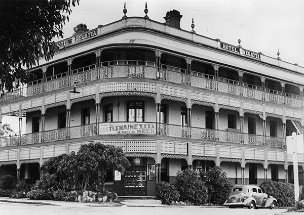
29. Regatta Hotel – 543 Coronation Drive, Toowong
A gracious landmark building along Coronation Drive, the Regatta Hotel was designed by notable Brisbane architect Richard Gailey during the 1880s economic boom. Built in 1886 to replace a modest single storey timber hotel, the Regatta Hotel is a substantial and resilient building that has since survived every significant flood in Brisbane.
Read more
Read more
The Telegraph reported that in the early hours of Sunday 14 March 1915, residents of Toowong and Hill End (South Brisbane) were woken by “piercing feminine shrieks, followed by the clanging of the fire bell”, as the back part of the Regatta Hotel was “sheeted in flames” with 7 people inside. The licensee, his wife and 4 children were prevented by intense smoke from escaping via the stairs and jumped from the front balcony. A maid, Grace Leis, was the only one seriously hurt, sustaining back and internal injuries and suffering shock.
In 1926, the Federated Liquor Trade Employees’ Union declared the Regatta Hotel ‘black’ after a bar attendant was unfairly dismissed. During the industrial dispute that lasted only 4 days, the Federated Carters’ Union also refused to make deliveries to the hotel, impacting its beer and spirit supplies.
Another controversy occurred on 31 March 1965 when two women, Merle Thornton and Rosalie Bogner, chained themselves to a footrail in the men-only public bar to protest the exclusion of serving women in public bars. This Queensland liquor law was changed in 1970 and, in 2014, the Regatta Hotel named Merle’s Bar to honour the protest.
Mother of Australian actor Sigrid Thornton, Merle was a strong advocate for women throughout her academic career focused on sociology, gender studies, women's studies, philosophy, and government. She founded the Equal Opportunities for Women Association, and successfully campaigned to remove the ‘marriage bar’ that, until 1966, excluded married women from working in the Australian public service.
For more information about this State heritage place, visit the Queensland Heritage Register.
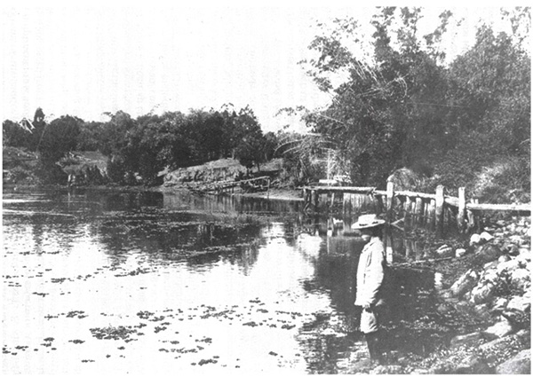
30. Kayes Rocks – Glenny Street, Toowong
Kayes Rocks is a park reserve comprising 5 terraces and stone retaining walls that cascade to the river edge. It was once an area of road reserve with a steep rocky bank but in 1933 Brisbane City Engineer’s Office drew plans for its beautification. The original plans included circular paths to the first and second terraces, but these were replaced in the final design with a central path. Beautification works were undertaken in the 1920s as part of a Queensland Government relief work scheme to provide unemployment during the Great Depression.
Read more
Read more
The beautification scheme by the Queensland Government for Kayes Rocks was probably undertaken using intermittent relief work labour. Relief funds enabled Brisbane City Council to proceed with many civic beautification schemes that otherwise would have been achieved by sacrificing elements of larger infrastructure projects, like the upgrading and extending of the sewerage system.
The Kayes Rocks reserve is thought to be named after Samuel Kaye, a professor of music, dealer in musical instruments, and Toowong resident who lived adjacent to the reserve. Kaye arrived in Queensland in 1876 and died at his home in 1896. It is thought that his residence was known as “Kaye’s Rocks".
For more information about this Local heritage place, visit Local Heritage Places online.
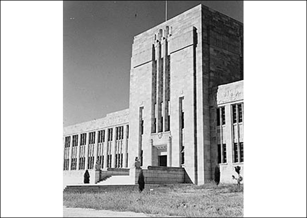
31. University of Queensland, Great Court Complex – 12 Upland Road, St Lucia
While proposals for a Queensland university began in the 1870s, it was not until 1893 after 2 Royal Commissions that a group of private individuals called the Queensland University Extension Movement organised public courses for adult education. In 1894, 245 students were enrolled in extension classes, emphasising the practical aspects of university education and its importance for Queensland commerce.
Read more
Read more
In 1906 after growing political momentum, 60 acres in Victoria Park were gazetted for university purposes.On December 10, 1909, an Act of the Queensland State Parliament established the University of Queensland to commemorate the 50th anniversary of Queensland's separation from the colony of New South Wales. Old Government House in George Street was set aside for the university and, in 1910, the first teaching faculties were created for engineering, classics, mathematics and chemistry.
The selection of a permanent university location was controversial. Shortlisted sites such as Old Government House were deemed too small and building on Victoria Park’s sloping grounds too costly. In 1926, Dr James O'Neil Mayne and Mary Emilia Mayne made £50,000 available for Brisbane City Council to resume land at St Lucia for the purposes of establishing the university.
In 1937, Queensland Premier, William Forgan Smith laid the foundation stone and, in 1938 construction started with the main building, now known as the Forgan Smith Building, followed by lower floors of the library and chemistry buildings. In clockwise stages, building proceeded after the Second World War to form what is now known as the Great Court.
Designed by Hennessy, Hennessy & Co, the Great Court Complex is semicircular in plan and features a continuous colonnade linking 5 buildings clad in attractive Helidon sandstone that varies in colour ranging from rich purples to creams and tans.
For more information about State heritage place, visit the Queensland Heritage Register.
Looking for more?
Looking for more?
Disembark the CityCat at the UQ St Lucia ferry terminal and cross Eleanor Schonell Bridge to visit the Local heritage place, Dutton Park and the State heritage place, South Brisbane Cemetery.
32. Dutton Park reserve – 359 Gladstone Road, Dutton Park
Since its early days, Dutton Park has been a popular nature refuge within an urban environment. Nearby residents in the late 19th Century fought passionately against attempts to develop the park, proclaiming that such a healthy and beautiful site so near to the city centre was indispensable.
Read more
Read more
When Dutton Park reserve was established in 1884, it was seen as more than just a pleasant leisure site. Like many other rapidly urbanising cities, Brisbane had a long running sanitation problem marked by overflowing cesspits, piles of refuse, and foul-smelling pools of stagnant water. In such conditions, parks and gardens – often romantically described as ‘lungs of the city’ – were valuable refuges of clean, unspoiled land, considered essential for the health, wellbeing, and even morality of city residents.
Dutton Park quickly earned a valued place in the local community. In 1900, a plan to absorb the reserve into the burgeoning South Brisbane Cemetery provoked outrage from more than 300 local petitioners who wrote passionately to the Brisbane Courier to denounce the ‘barbarous proposal’ to remove the park. Their efforts were successful and the park remained.
A more popular development, in 1908 the park was re-opened after being leased to the Brisbane Tramways Company. Now easily accessible from the city via tram, Dutton Park became a popular venue for picnics, cricket matches, open-air concerts and evening film screening that drew crowds of up to 5,000 people.
The 1930s ushered in a very different use for the park as men made homeless by the Great Depression began to reside there. Seats were requisitioned for firewood and a sprawling shanty town sprang up, housing hundreds of residents until the effects of the Depression eased.
Park improvement and expansion continued through the following decades and, in 1967, a ferry route opened from Dutton Park to the University of Queensland, St Lucia. Demand for the ferry route was driven by a University of Queensland Union petition, later revealed to be a student prank. Nevertheless, the ferry proved popular, and was only discontinued in 2006 after construction of the Eleanor Schonell Bridge put Dutton Park within walking distance from St Lucia.
For more information about this Local heritage place, visit Local Heritage Places online.
Listen to related historical narration
Listen to related historical narration
Theatrical events enjoyed at the Dutton Park Garden Theatre, 1910.