Wildlife Awareness Monitors
Council has installed Wildlife Awareness Monitors (WAMs) as part of an initiative to help protect and maintain our city's biodiversity.
About the initiative
Council has installed 50 WAMs at high-priority wildlife sites across Brisbane since December 2019. The initiative alerts drivers to the potential presence of wildlife to reduce the risk of animal strikes and increase driver awareness of high wildlife presence on our roads.
As part of this initiative, WAMs have been installed at the following sites:
| Suburb | Road | Direction | Details |
|---|---|---|---|
Anstead | Hawkesbury Road | Northbound | Near Witty Road |
Anstead | Hawkesbury Road | Southbound | Near Essendon Road |
Belmont | Mount Petrie Road | Northbound | Near Greendale Way |
Belmont | Mount Petrie Road | Southbound | North of Brisbane Gun Club access |
Burbank | Ford Road | Northbound | Opposite property 350 |
Burbank | Ford Road | Southbound | Near property 300 |
Cannon Hill | Creek Road | Northbound | Approaching Minnippi Boulevard |
Cannon Hill | Creek Road | Southbound | Approaching Minnippi Boulevard |
Carindale | Creek Road | Northbound | Near Bendena Terrace |
Carindale | Creek Road | Southbound | Near Weekes Road |
Carindale | Old Cleveland Road | Eastbound | Near Bridgnorth Street |
Carindale | Old Cleveland Road | Westbound | Near Bridgnorth Street |
Carindale | Scrub Road | Northbound | Near Oakley Street |
Carindale | Scrub Road | Southbound | Near Cribb Road |
Carindale | Winstanley Street | Eastbound | Near Surbiton Court |
Carindale | Winstanley Street | Northbound | Near Firmiston Street |
Chandler | Mt Gravatt-Capalaba Road | Eastbound | 260m west of Geldart Road |
Chandler | Mt Gravatt-Capalaba Road | Westbound | Near property 1739 |
Chermside West | Hamilton Road | Eastbound | Near Keaton Street |
Chermside West | Hamilton Road | Westbound | Near Keaton Street |
Coorparoo | Boundary Road | Northbound | North of Cavendish Road |
Coorparoo | Boundary Road | Southbound | South of Whites Hill Reserve access |
Coorparoo | Boundary Road | Northbound | North of Whites Hill Reserve |
Coorparoo | Boundary Road | Southbound | Near Indus Street |
Drewvale | Illaweena Street | Eastbound | Near Gateway Motorway underpass |
Mansfield | Pine Mountain Road | Eastbound | Opposite Gretna Street |
Mansfield | Pine Mountain Road | Westbound | Adjacent Turubul Crescent Park |
McDowall | Beckett Road | Northbound | South of Cabbage Tree Creek |
McDowall | Beckett Road | Southbound | South of Saturn Crescent |
McDowall | Rode Road | Eastbound | Near Trouts Road |
McDowall | Rode Road | Westbound | Approaching Appleby Road |
Mount Crosby | Wattle Street | Northbound | Near Mount Crosby Road |
Mount Crosby | Swensons Road | Southbound | Near Flaggy Creek Road |
Mount Gravatt East | Cavendish Road | Northbound | Near Camlet Street |
Mount Gravatt East | Cavendish Road | Southbound | Near Nursery Road |
Mount Gravatt East | Logan Road | Northbound | Opposite Showgrounds |
Mount Gravatt East | Logan Road | Southbound | Adjacent service station |
Nathan | Toohey Road | Southbound | Near Toohey Forest car park |
Pullenvale | Pullenvale Road | Westbound | Near property 246 |
Ransome | Rickertt Road | Eastbound | 330m east of Green Camp Road |
Ransome | Rickertt Road | Westbound | 30m west of driveway of #101 |
Salisbury | Orange Grove Road | Northbound | Near Pevny Street |
Salisbury | Orange Grove Road | Southbound | Near Allandale Street |
Sumner | Wacol Station Road | Northbound | Adjacent #360 |
Sumner | Wacol Station Road | Southbound | 250m south of Sumners Road |
Sumner | Wolston Road | Eastbound | Near Wolston Road Park |
Sumner | Wolston Road | Westbound | Near Pooh Corner |
Wacol | Wilruna Street | Southbound | Near bus stop |
Wynnum West | Wynnum Road | Southbound | Near Kianawah Road |
Wynnum West | Wynnum Road | Eastbound | Near Fleming Road |
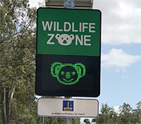
How the monitors work
WAMs are permanent installations and are solar‑powered. Messaging on the signs is customised, based on wildlife movements across the seasons, such as during breeding or Joey season.
The monitors are installed with radars that detect vehicles speeds as vehicles approach. Depending on the vehicle's speed, one of the following two messages is displayed.
- A smiling koala face is displayed when the driver is travelling at or below the posted speed limit.
- A 'slow down' message is displayed if the driver is travelling above the speed limit.
The purpose of monitors is to alert drivers to their speed to improve road safety and minimise the risk of animal strikes, not to issue infringement notices.
Other road safety initiatives
Further to the success of the WAMs and Speed Awareness Monitors (SAMs), Council has installed Automated Flooded Road Warning Systems (AFRWS). These systems help to improve motorist awareness of flooded road conditions during periods of heavy rainfall and reduce the risk of motorists driving into floodwaters.
More information
If you would like to find out more about Wildlife Awareness Monitors, you can:
- phone Council on 07 3403 8888
- email the project team
- write to:
Wildlife Awareness Monitors
Transport Planning and Operations
Brisbane City Council
GPO Box 1434
Brisbane Qld 4001.