Greater Brisbane key corridors performance January-June 2018
Greater Brisbane road network
This report provides information on the traffic volume and average speed for the Greater Brisbane key transport corridors over the January to June 2018 period. The corridors include Brisbane City Council (Council) and Department of Transport and Main Roads (TMR) managed roads. Network summaries are presented in vehicle kilometres travelled (VKT) and average network speeds. The report includes information on initiatives being undertaken by both organisations to manage congestion on the road network.
Report findings
There are 38 key corridors, comprising 317.2 km of road, in the Greater Brisbane area. Council manages 18 of these corridors, equating to 102.1km of road and TMR manages the other 20, equating to 215.1 km of road.
Network vehicle kilometres travelled remained consistent compared to the same period last year.
| Peak average network speed details | Speed |
|---|---|
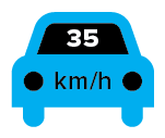
Weekday AM peak average network speed is 35 km/h:
| |
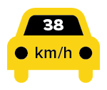
Weekday PM peak average network speed is 38 km/h:
|  |
- Bruce Highway (managed by TMR) is the busiest corridor with an average volume of 161,995 vehicles per day.
- Cleveland Redland Bay Road (managed by TMR) is the least busy corridor with 20,573 vehicles per day.
- In the AM peak, February had the lowest average speed at 31 km/h, while January had the highest average speed at 39 km/h.
- In the PM peak, February had the lowest average speed at 36 km/h, while April had the highest average speed at 41 km/h.
- In the AM peak:
- Centenary Motorway between Logan Motorway and Ipswich Motorway (managed by TMR) had the fastest average speed at 75 km/h (100 km/h speed limit)
- Stanley Street (managed by Council) had the slowest average speed at 16 km/h (speed limit is 60 km/h with a school zone speed of 40 km/h on this corridor).
- In the PM peak:
- Centenary Motorway between Logan Motorway and Ipswich Motorway (managed by TMR) had the fastest average speed at 95 km/h (100 km/h speed limit)
- Stanley Street (managed by Council) had the slowest average speed at 22 km/h (60 km/h speed limit in the PM Peak).
- On Council’s 18 key corridors, compared with the same period in 2017:
- AM peak average speed decreased by 4.2% from 27 km/h to 26 km/h
- PM peak average speed decreased by 2.0% from 33 km/h to 32 km/h.
- On 19 of TMR’s 20 key corridors (excluding Old Northern Road), compared with the same period in 2017:
- AM peak average speed decreased by 7.8% from 42 km/h to 39 km/h
- PM peak average speed decreased by 5.0% from 44 km/h to 42 km/h.
Compiled by Council, with data and analysis jointly undertaken by Council and Department of Transport and Main Roads. Incident data provided by the Brisbane Metropolitan Transport Management Centre (BMTMC).
Greater Brisbane Key Corridors
The volume and speed of the 38 key corridors in the current reporting period (January – June 2018) is compared with the same period in previous year (2017). All traffic volume data takes into account both directions of travel. It includes weekdays only and excludes public holidays. Traffic volumes on TMR’s corridors were taken at the road segment with the highest volume. Council corridor traffic volumes were taken in the middle segment of the corridors.
The average daily traffic volume for the month is the number of vehicles utilising the corridor per day, averaged over all weekdays of the month (excluding public holidays).
AM peak period for TMR corridors is from 6am to 9am as the TMR network is utilised earlier, particularly on the outer edges of the Greater Brisbane road network (for example, the Bruce Highway and the Pacific Motorway). AM peak period for Council corridors is from 7am to 9am. PM peak periods are the same for both TMR and Council corridors, 4pm to 7pm. The monthly AM and PM peak per hour traffic volumes are the average hourly volume for the month over the corresponding AM and PM peak periods, respectively.
Note: Speed data was not available for Old Northern Road (between Albany Creek Road and Stafford Road) during the January – June 2017 period. The route was excluded from the network vehicle kilometres and network speed summary charts.
Volume data for January – June 2017 and June 2018 was not available for Bruce Highway. An adjustment was made in the network and route calculations.
Volume data for January – February 2018 and April – June 2018 was not available for Old Northern Road. An adjustment was made in the network and route calculations.
Volume data for March – June 2018 was not available for Beaudesert Road. An adjustment was made in the network and route calculations.
Volume data for April – June 2018 was not available for Ipswich Motorway. An adjustment was made in the network and route calculations.
Table: Greater Brisbane Key Corridors January to June 2018
Network vehicle kilometres travelled summary
Average vehicle kilometres travelled on 38 key corridors by month.
Traffic volume and vehicle kilometres travelled
Vehicle kilometres travelled (VKT) is a measure of traffic demand on the road network. It is the length of a section of road in kilometres multiplied by the average traffic volume on that section. The daily VKT is the product of the length of the road and average daily traffic (ADT). The monthly VKT is the daily VKT multiplied by the number of weekdays in the analysis period.
The AM peak monthly VKT is the product of the length of the road, the average AM peak hourly traffic volume and number of weekdays in the analysis period.
The PM peak monthly VKT is the product of the length of the road, the average PM peak hourly traffic volume and number of weekdays in the analysis period. The network VKT is the sum of all the corridors in the network.
Table: Greater Brisbane network vehicle kilometres travelled January to June 2017 to 2018
Use the dropdown menu to change between Brisbane City Council, TMR or Greater Brisbane (all) key corridors.
Average network speed summary
Average speed of 38 key corridors
Average speed in kilometres per hour is a measure of traffic efficiency on the road network. Average speed is calculated using travel times collected from TMR’s and Council’s extensive network of Bluetooth scanners within the Greater Brisbane road network. Average corridor speed includes delays at signalised intersections. Average travel times were collected during the AM and PM peak periods to calculate the average speed of the corridor. Peak periods are similarly defined as in the VKT calculations. AM peak travel time is taken as the inbound direction while the PM peak travel time is the outbound direction.
Table: Greater Brisbane network average speed January to June 2017 to 2018
Use the dropdown to change between Brisbane City Council, TMR or Greater Brisbane (all) key corridors.
State Government Congestion Initiatives
Transport and Main Roads (TMR) has a number of policies, strategies and projects which are addressing traffic congestion and journey reliability in Greater Brisbane, including those listed below.
- Travel options and travel information – creating a public transport and active transport network that has greater accessibility, frequency and reliability (ongoing funding of principal cycle network, QLDTraffic website and smartphone app, real time-bus information, enhanced train timetable). QLDTraffic was launched in February 2017, providing dynamic and real-time travel information through a new website https://qldtraffic.qld.gov.au/ and a smartphone app.
- Improved incident management including traffic response units (with Council).
- Managed motorway operations (for example, ramp signalling, Ipswich Motorway Lane Use Management and Variable Speed Limit operations).
- Increased capacity – there have been significant projects to address the growing traffic demands on the road network such as M1/M3 Gateway merge, Gateway Upgrade North and Ipswich Motorway.
M1/M3 Gateway merge upgrade
TMR is working to alleviate congestion on the Pacific Motorway between Eight Mile Plains and Rochedale.
The M1/M3 Gateway merge upgrade includes:
- widening up to five southbound motorway lanes between Eight Mile Plains and Rochedale South (Exit 19)
- relocation of the existing bus entry from the Eight Mile Plains Bus Station onto the Pacific Motorway to south of Underwood Road
- replacement of the Underwood Road bridge to a new four lane overpass
- managed motorway technologies from Klumpp Road to Rochedale Road in both directions.
This project will reduce congestion, improve travel times for motorway users, improve travel time reliability for motorway and public transport users, increase freight efficiency and improve safety.
The $190 million upgrade is jointly funded by the Australian Government ($115 million) and the Queensland Government ($75 million).
The M1/M3 Gateway merge commenced construction in April 2018 and is scheduled for completion in mid-2020.
This project is Stage 1 of the M1 Masterplan (Gateway to Logan Motorways) which is being delivered in priority stages as funding becomes available.

Gateway Upgrade North (GUN)
This $1.143 billion project will ease congestion and improve safety on one of Queensland’s busiest motorways. Once completed, the project from Nudgee to Bracken Ridge will increase capacity and freight efficiency along this important corridor.
Carrying more than 83,000 vehicles a day, the Gateway Motorway experiences high levels of congestion. The project will improve travel time reliability, safety, and connectivity increasing the efficiency of the Gateway Motorway.
This project will upgrade the motorway from four to six lanes between Nudgee and Deagon, with additional pavement rehabilitation and safety works through to Bracken Ridge. It also includes:
- reconfiguring the Nudgee interchange including a new Nudgee Road overpass
- widening of the Deagon Deviation to two lanes in each direction between Depot and Bracken Ridge Roads
- the provision of a grade-separated interchange between the Gateway Motorway and the Deagon Deviation at Deagon
- construction of a new off-road cycle path connecting to local networks
Major construction activities commenced in early 2016 and works are well underway across the length of the project. The project is on track for completion in late 2018.
The Gateway Upgrade North project is jointly funded by the Australian Government ($914.18 million) and Queensland Government ($228.54 million) on an 80:20 split. The upgrade is being delivered by TMR, with Transurban Queensland engaged to assist in managing the delivery of the major works package.

Ipswich Motorway Upgrade: Rocklea to Darra – Stage 1 project
The Ipswich Motorway Upgrade: Rocklea to Darra – Stage 1 project (R2D – stage 1) is a $400 million project jointly funded by the Australian Government and the Queensland Government, with each committing $200 million.
The project covers the three kilometre section from Granard Road, Rocklea to east of Oxley Road, Oxley. This is the most critical section of the remaining seven kilometre section of the motorway, still to be upgraded. Upgrading the remaining four kilometres of the Ipswich Motorway, between Oxley Road and the Centenary Motorway, is still a priority, but subject to available funding.
The local community and businesses will benefit from the upgrade through improved road safety and better local connectivity. Motorists on this section of the Ipswich Motorway will also benefit from improved traffic flow and improved flood immunity.
In July 2018, the scope of the Stage 1 project changed to include the Boundary Road Connection. This involves design and construction of a 1.5 kilometre missing link from the existing Boundary Road, east of Oxley Creek, to the existing Boundary Road at the Blunder Road intersection, west of Oxley Creek. This will be delivered within the committed $400 million funding.
Works on this section now includes:
- seven new, higher bridges over Oxley Creek
- new southern service road connecting Boundary Road, east of Oxley Creek to the existing Boundary Road at the Blunder Road intersection, west of Oxley Creek
- new northern service road connection over the Oxley Creek floodplain
- new active transport facilities on the northern service road
- new traffic signals at the Suscatand Street intersection
Works will be staged to effectively manage the upgrade of the motorway while under live traffic conditions.
Milestones achieved since construction commenced in late October 2017 include:
- closure of Donaldson Road exit ramp – 25 October 2017
- closure of Boundary Road exit ramp – 4 February 2018
- start of piling works for bridge construction – 18 April 2018
- announcement of the inclusion of Boundary Road Connection – 25 July 2018.
Construction is expected to be completed late 2020.

Ipswich Motorway Ramp Signals
TMR activated on-ramp signalling along the Ipswich Motorway between the Centenary Motorway and the Warrego Highway, Dinmore. The on-ramp signals were switched on in mid-May 2018 and the signals activate when the motorway is congested, or in response to an incident.
Ramp signals are used throughout areas of South East Queensland to manage traffic demands of road users accessing motorways during peak times, to delay the onset of congestion and to assist in recovery from flow breakdown and congestion.
The locations of the ramp signals to be activated along Ipswich Motorway are:
- Brisbane Road on-ramp eastbound at Dinmore
- Mine Street on-ramp eastbound at Redbank
- Francis Street on-ramp eastbound at Redbank
- Brisbane Road on-ramp westbound at Goodna
- Church Street on-ramp eastbound at Goodna
- Progress Road on-ramp westbound at Wacol
- Wacol Station Road on-ramp eastbound at Wacol.
Variable Speed Limit Signs – Western Freeway (Outbound)
The Variable Speed Limit signs (VSLS) along a four kilometre stretch of the Western Freeway (outbound), between Waverley Road Overpass and Fig Tree Pocket Road Overpass, have been operational since July 2018.
TMR is taking steps to reduce the potential of accidents and reduce congestion for the 37,000 road users who travel this Western Freeway section daily.
This section of road experiences a high level of congestion during afternoon peak periods and will greatly benefit from VSLS. VSLS will change speed limits in gradual steps to optimise flow and improve travel time.
Safety benefits will include the reduction of secondary incidents (rear end crashes).
New VSLS have been installed at the following six locations:
- after Waverley Road Overpass
- near Moggill Road off-ramp
- on Moggill Road on-ramp
- after Russell Terrace/Moggill Road on-ramp
- after Jerrang Street Overpass
- on Fig Tree Pocket Road on-ramp
Logan Enhancement Project (funded by Transurban Queensland)
Transurban Queensland’s $512 million Logan Enhancement Project includes widening sections of the Logan and Gateway motorways, improving key congestion hot spots (Logan Motorway/Mount Lindesay Highway/Beaudesert Road interchange and the Wembley Road/Logan Motorway interchange) and constructing new south-facing ramps on the Gateway Motorway at Compton Road.
The project will improve safety and reliability, reduce travel times, enhance connectivity to key residential and business areas, and future proof the network.
The project involves:
- widening the Logan Motorway between Mount Lindesay Highway and Wembley Road interchanges, with a minimum of three lanes in each direction
- widening the Gateway Motorway between Compton Road and the Logan Motorway interchange, to provide three lanes in each direction
- upgrading the Mount Lindesay Highway/Beaudesert Road interchange to remove traffic conflict points and weave movements to improve both safety and interchange efficiency
- upgrading the Logan Motorway/Wembley Road interchange, including the provision of new entry and exit ramps and widening Wembley Road to provide two lanes in each direction between Pagewood Street and Greenfern Drive.
The project is the first Market-Led Proposal to be approved in Queensland.
CPB Contractors, a member of the CIMIC Group, is undertaking detailed design and construction of the project. The project will support 1300 direct jobs during construction and generate approximately $1.2 billion in economic benefits for Queenslanders over 30 years.
Construction of the project commenced in June 2017, with detailed design now complete. Construction is scheduled to be completed in mid-2019.

Council congestion initiatives
Major Projects
Council is committed to reducing congestion and improving safety and access across the city through a network-wide focus on traffic improvements to meet current and future traffic volumes along Brisbane’s road network corridors. This aligns with Council’s new Transport Plan for Brisbane – Strategic Directions that will guide the evolution of our transport network over the next 25 years and beyond.
Key projects including major road construction and intersection upgrades support Council’s commitment to building an improved road and transport network across Brisbane. To improve access to major transport networks, Council is also working to minimise traffic congestion and to improve safety in local areas by modifying intersections, introduce corridor upgrades and minor road projects.
Some of the major projects are profiled below.
Inner City Bypass upgrade
The Inner City Bypass (ICB) is Brisbane’s busiest arterial road under Council’s control and has been operating at up to 90% capacity. It is a vital link in the road network with connections to Lutwyche Road, Airport Link Tunnel, Clem Jones Tunnel, Legacy Way tunnel and the soon-to-be-upgraded Kingsford Smith Drive.
With the ICB now carrying more than 105,000 vehicles per day, the road would have exceeded capacity by 2021 without intervention.
Growth across Brisbane is expected to generate approximately 25,000 additional vehicle trips on the ICB per weekday by 2031, with the average daily traffic volume expected to grow to 128,000 vehicles per weekday.
The ICB upgrade increases capacity for existing and future traffic demands, improves travel times and safety for all road users, and improves connectivity to the wider road network.
ICB has been widened from three to four lanes in each direction between Legacy Way and the RNA tunnel, providing estimated travel time savings of up to 25% for all vehicles.
New and improved ICB entry and exit points allow bus users to experience reduced travel times and provide opportunities for new bus services to operate to and from the western suburbs using Legacy Way.
The new westbound on-ramp to the ICB from Bowen Bridge Road and the Inner Northern Busway allows bus services to use the Legacy Way tunnel in both directions. A number of inbound bus services have already been re-routed to take advantage of Legacy Way.
Since the tunnel opened in 2015, bus users have experienced average journey time savings of up to 13 minutes and patronage has also increased by 52% on inbound bus services.
The new westbound on-ramp provides travel time savings of approximately 10 minutes for buses heading towards western suburbs and allows buses to interchange with the Inner Northern Busway and the planned Brisbane Metro.
The ICB upgrade is an initiative of Brisbane City Council and was delivered by Transurban Queensland.


Wynnum Road corridor upgrade
The Wynnum Road corridor is a key arterial road in Brisbane’s road network, providing access for more than 56,000 vehicles between suburban and commercial catchments in the eastern suburbs of Brisbane, the Central Business District (CBD) and beyond.
Council is delivering the upgrade to the Wynnum Road corridor in stages.
Stage 1
Stage 1 of the project will see Lytton Road between Latrobe Street and Canning Bridge in East Brisbane widened from four to six lanes by 2020, to help cater for existing and future traffic demands along this busy corridor. The upgrade will see travel times in this section of Lytton Road reduced by approximately 50% in peak periods.
Stage 1b
Stage 1b will provide interim measures to improve traffic efficiency and safety along the corridor between Canning Bridge in East Brisbane and Riding Road in Norman Park.
The Stage 1 and 1b upgrades will improve safety and traffic flow along the corridor by:
- widening Lytton Road from Latrobe Street to Canning Bridge from four to six lanes
- increasing lane widths on Lytton Road from Latrobe Street to Canning Bridge to an appropriate standard
- removing unsafe right turns into private properties and side streets
- upgrading the bend at Heidelberg Street
- improving the Norman Avenue intersection including a new U-turn facility for westbound traffic to travel eastbound
- relocating and signalising the intersection at Laidlaw Parade and Lytton Road to provide a safe crossing point for pedestrians and cyclists
- installing a U-turn facility at a new Laidlaw Parade and Lytton Road intersection for westbound traffic to travel eastbound to support access to surrounding residential areas
- rationalising and indenting bus bays within the project area
- extending the bus jump lane from Bennetts Road to Hipwood Street.
Safety for pedestrians and cyclists will be improved by providing a designated two-way off-road cycle path and dedicated footpath between Mowbray Park and Laidlaw Parade, and a shared path between Mowbray Park and Wellington Road.
Construction commenced in March 2018 and is expected to be complete in early 2020.


Major Traffic Improvement Projects
Beckett Road and Hamilton Road intersection upgrade
The intersection of Beckett Road and Hamilton Road in McDowall is the crossing point of two major suburban roads in Brisbane’s north. The busy junction has an average of 41,000 vehicles passing through each day.
The intersection is exceeding capacity during both morning and afternoon peaks. Without intervention the significant queuing and travel time impacts that are currently experienced will deteriorate.
The improvement project aims to increase capacity and reduce congestion through the intersection, particularly during peak times. At present, the average AM peak time delay for Hamilton Road (west) through movement is greater than 180 seconds with a recorded queue length of 320 metres. During the PM peak, the average delay for Hamilton Road (east) right-turn movements is greater than 120 seconds with an overall queue length of 402 metres.
The upgrade will also improve safety and access for all road users. From January 2012 to December 2017, there were 12 reported crashes at the intersection with seven requiring medical treatment and one hospitalisation. 58% of the accidents involved rear-end collisions while 33% involved accidents with the filtered right-turn movement.
The upgrade involves widening Hamilton Road to allow the installation of an additional lane in each direction and the extension of the existing right-turn lanes to create additional queuing space. Lane reconfigurations, additions and extensions on Beckett Road at the intersection will also help further traffic and efficiency improvements. Local residents west of the intersection will benefit from the creation of a right-turn pocket into Speilberg Street to separate through and turning traffic on Hamilton Road westbound.
The upgrade will ensure the intersection is prepared for future traffic growth and supports improved connectivity on the local road network.
A key consideration in Council’s commitment to congestion busting projects is about getting people home quicker and safer. The improved efficiency delivered by the Beckett Road and Hamilton Road intersection upgrade will benefit residents in the local area.
Construction began in February 2018 and was completed in July 2018.

Green Camp Road corridor upgrade
Council is upgrading Green Camp Road between Manly Road and Rickertt Road, with joint funding from Council and the Australian Government through the Department of Infrastructure and Regional Development.
The $27.7 million upgrade will improve safety by upgrading and signalising the Green Camp Road and Tilley Road intersection, and by improving the layout and alignment of the Green Camp Road and Rickertt Road intersection. The project will also reduce travel times along Green Camp Road by widening the existing road from two to four lanes.
The upgrade will improve safety for road users, reduce traffic congestion and improve travel time reliability along the corridor. Once completed, the upgrade will enhance the ability for Green Camp Road to fulfil its role as an arterial road in the east Brisbane network.
Features of the upgrade include:
- providing a minimum of two through lanes in each direction on Green Camp Road from Manly Road to approximately 180 metres past the Rickertt Road intersection
- providing three through lanes on the Green Camp Road northbound carriageway adjacent to the Tilley Road intersection
- signalising the Green Camp Road and Tilley Road intersection including widening the Tilley Road approach to provide one left-turn lane and one right-turn lane
- providing two through lanes on Rickertt Road in each direction for 200 metres from the Green Camp Road intersection
- widening the Rickertt Road approach to provide a separate left-turn lane and two right-turn lanes
- raising the road level and upgrading the existing culverts under the Green Camp Road and Tilley Road intersection to improve drainage and flood immunity to a one per cent annual exceedance probability (one in 100 year probability of a flood occurrence)
- providing on-road cycle lanes and off-road shared paths
- providing fauna crossing facilities, fauna fencing and wildlife awareness zones
- providing improved pedestrian footpath connections
- a new car park 250 metres north of the Green Camp Road and Tilley Road intersection for visitors to Green Camp Road Park
- landscaping treatments.

Congestion busting projects
Arterial Road Program (ARP)
Brisbane City Council’s Arterial Road Program (ARP) delivers low-cost, high-impact projects to reduce traffic congestion across Brisbane.
The ARP uses reputed traffic signal intersection modelling software, SIDRA (Signalised and unsignalised Intersection Design and Research Aid), as the primary decision-making tool to determine the value for money of project works undertaken.
The following case studies look at two types of projects delivered from the ARP. The first type reconfigures existing road space by making changes to line markings, medians and signage. The second type involves the construction of additional road space on the network to achieve minor road widening or lengthening.
Case Study: Road space reconfiguration
Example: Ann Street between Roma Street and George Street, Brisbane City
Ann Street is classified as an arterial road under Council’s Road Hierarchy. It is an important link in the Central Business District and Fortitude Valley.
Ann Street, between Roma Street and George Street, carries approximately 1,600 vehicles per hour (vp/h) and 2,000 vp/h in the AM and PM peaks respectively.
Ann Street was realigned to provide three continuous through lanes, with a right turn lane formed 50 metres before the George Street intersection. As a result, the bus lane was modified to end 110 metres before George Street.
This low-cost, high-impact project was delivered in February 2018. Travel time comparison of pre and post project implementation showed reductions of 6% and 9% in AM and PM peaks respectively.


Case study: Road space reconfiguration
Example: Hamilton Road at Gympie Road, Chermside
Hamilton Road is classified as an arterial road under Council’s Road Hierarchy. It extends from Sandgate Road to Old Northern Road and carries an average daily volume of 35,000 vehicles.
The demand on the western approach on Hamilton Road at Gympie Road often extends beyond the available two lane queue capacity, with motorists informally queuing side by side to move through the intersection quicker. This practice is illegal and risks the safety of motorists.
To address this congestion and safety concern, Council extended the two eastbound lanes by 290 metres to allow additional capacity for queuing and improved traffic flow.
This work was achieved by relocating the centre line slightly south to provide sufficient lane width for the eastbound carriageway.
This high-impact project was delivered in February 2018.


Congestion Busting Projects January to June 2018
The following projects were completed within this reporting period.
Street location | Suburb | Project description | Completed |
|---|---|---|---|
Ann Street between Roma Street and George Street | Brisbane City | Realigned the lane arrangement to streamline the flow of vehicles travelling through the intersections | Feb 18 |
Appleby Road at Coleridge Street | Stafford Heights | Provision of a right turn from Appleby Road into Maryland Street. Converted Coleridge Street into left-in/left-out and extended the right turn lane from Appleby Road into Giles Street | Jun 18 |
Beenleigh Road at Stones Road | Sunnybank Hills | Provision of a right turn lane from the south approach of Stones Road into Beenleigh Road | Jun 18 |
Belmont Road at Manly Road | Tingalpa | Extended turn lanes on Belmont Road | May 18 |
Ellison Road at Kirby Road | Aspley | Provision of a right turn lane from Ellison Road into Kirby Road | Apr 18 |
Granadilla Street at McCullough Street | MacGregor | Extended the right turn lane from Granadilla Street into McCullough Street | Mar 18 |
Ham Road at Broadwater Road | Mansfield | Extended the right turn lane on the northern intersection approach | May 18 |
Hamilton Road at Gympie Road | Chermside | Extended two approach lanes on Hamilton Road | Feb 18 |
Junction Road at Kates Street | Morningside | Provision of a right turn lane on Junction Road into Kates Street | Feb 18 |
Norris Road at Bracken Ridge Road | Bracken Ridge | Extended both turn lanes on Norris Road at the Bracken Ridge Road intersection | Feb 18 |
Rode Road at Gympie Road | Chermside | Extended a right turn lane on Rode Road at Gympie Road | Mar 18 |
Rode Road at Parkdale Street | Chermside | Provision of a right turn lane on Rode Road at Parkdale Street | Feb 18 |
Rose Street at Dawson Street | Wooloowin | Extended the approach lanes on Dawson Street south | Jun 18 |
Swann Road at Moggill Road | Taringa | Extended left turning lanes from Swann Road | Jun 18 |
Toombul Road at Nudgee Road | Northgate | Extended right turn lanes on both Toombul Road north west approach and Nudgee Road south west approach | Jun 18 |
Toombul Road at St Vincents Road | Virginia | Implemented parking restrictions on St Vincents Road approaching Toombul Road | May 18 |
Webster Road at Gympie Road | Aspley | Extended the right turn lane from Webster Road southern approach into Gympie Road by shaving the median | Jun 18 |
Yallambee Road at Curragundi Road | Jindalee | Created a right turn lane from Yallambee Road into Curragundi Road | Jun 18 |
Factors affecting network performance
Traffic volume and travel times are also affected by other factors, including traffic incidents. These incidents, such as accidents, extreme weather and planned events, influence the amount of congestion experienced on the roads. Depending on the timing, location, severity and duration, an incident may have minimal effect on the road network or cause gridlock in large parts of the city.
Specific incidents can have a greater impact on the road network. Emergency works, for example water main repairs on the Bruce Highway, can have a significant impact on the average incident clearance times, and hence the journey times. Incidents that require emergency service attendance can take up to four hours to clear, depending on the severity and location of the incident.
There are also locations within the city that are particularly susceptible to excess congestion when a minor incident happens. Examples of these include Hale Street and Merivale Street.
The BMTMC continue to proactively manage the impacts of incidents as they happen to minimise effects on residents, businesses and travellers within Greater Brisbane. The data detailed in this report specifically analysed significant unplanned incidents that had the potential to have a major impact on the road network. BMTMC collected and compiled this incident data for roads throughout the Greater Brisbane metropolitan area.
Significant incident data
This data is a collection of traffic crashes, hazards and stationary vehicles that impacted the road network. These are defined as unplanned incidents. It does not cover planned events/roadworks, alerts, congestion incidents, or quick clearance towing for TMR and Council clearway towing.