Reflections on the River Trail
Walk the Reflections on the River Trail to discover the role the Brisbane River has played in our city’s history.

About the Reflections on the River Trail
The Brisbane River has long been the defining feature of our city. Known as Maiwar to some Aboriginal and Torres Strait Islander peoples, the river has shaped thousands of years of history.
It has also played a significant part in the industrial and commercial transformation of modern Brisbane.
The river’s rich history is still marked by heritage buildings and historical sites that characterise the Town Reach.
The Reflections on the River Heritage Trail winds along the riverfront of central Brisbane and explores:
- the importance of shipping to the city's commercial heritage
- the location of wharves, warehouses and workshops
- historic homes and government buildings
- the impact of floods on the city.
Reflections on the River Trail map
There are 29 points of interest along this 3.8-kilometre trail, beginning at Customs House and finishing at the Kangaroo Point boardwalk.
For addresses of all trail stops and suggested route between stops, download the trail guide.
Points of interest
427 Queen Street, Brisbane City
Get directions Customs House, Petrie Bight, c. 1920 (John Oxley Library, State Library of Queensland)
118 Eagle Street, Brisbane City
Get directions Intersection of Queen and Eagle Streets, 1889 (John Oxley Library, State Library of Queensland)
123 Eagle Street (view the Story Bridge from the Riverside Ferry Terminal on the City Reach Boardwalk), Brisbane City
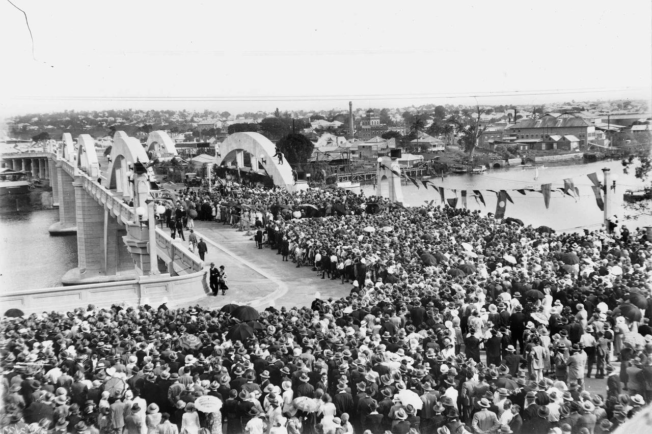
Get directions View of almost completed Story Bridge, c. 1939 (John Oxley Library, State Library of Queensland)
193 Mary Street, Brisbane City
Get directions Naldham House, c. 1935 (John Oxley Library, State Library of Queensland)
169 Mary Street, Brisbane City
Get directions47/51 Edward Street, Brisbane City
Get directions Edward Street during a flood in Brisbane, Spencers Building, 1890 (John Oxley Library, State Library of Queensland)
41 Edward Street, Brisbane City
Get directions Edward Street during March 1880 flood, 1880 (John Oxley Library, State Library of Queensland)
264 Margaret Street, Brisbane City
Get directions Corner of Queen and Edward streets, Brisbane, during 1893 flood, 1893 (John Oxley Library, State Library of Queensland)
40 Edward Street, Brisbane City
Get directions Port Office Hotel, c. 1929 (John Oxley Library, State Library of Queensland)
39 Edward Street, Brisbane City
Get directions Port Office, c. 1889 (John Oxley Library, State Library of Queensland)
32 Edward Street, Brisbane City
Get directions Building of Smellie & Co. Ltd. Hardware, Brisbane, Queensland, c. 1920 (John Oxley Library, State Library of Queensland)
3 Edward Street, Brisbane City
Get directions Naval Office and adjacent Water Police Offices, c. 1946 (John Oxley Library, State Library of Queensland)
2 Edward Street (corner with Alice Street), Brisbane City
Get directions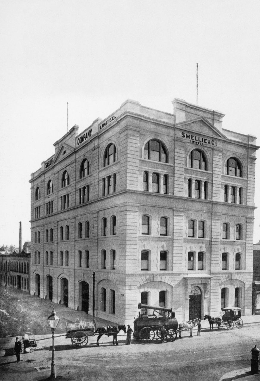
Building of Smellie & Co. Ltd. Hardware, Brisbane, Queensland, c. 1920 (John Oxley Library, State Library of Queensland)
210 Alice Street, Brisbane City
Get directions
Sketch of the Britannia Foundry building on Alice Street, undated (John Oxley Library, State Library of Queensland)
Alice Street entrance, Brisbane City
Get directions Botanic Gardens, c. 1896 (John Oxley Library, State Library of Queensland)
129 Margaret Street, Brisbane City
Get directions
Watson Brothers Building, c. 1882 (John Oxley Library, State Library of Queensland)
125 Margaret Street, Brisbane City
Get directions98 Margaret Street, Brisbane City
Get directions The Brisbane Synagogue, c. 1906 (John Oxley Library, State Library of Queensland)
40 George Street (corner of Margaret Street), Brisbane City
Get directions The Mansions building, c. 1908 (John Oxley Library, State Library of Queensland)
80 George Street, Brisbane City
Get directions Harris Terrace at the corner of George and Margaret streets, c. 1869 (John Oxley Library, State Library of Queensland)
99 William Street, Brisbane City
Get directions
Immigration Depot at William Street, c. 1868 (John Oxley Library)
115 William Street, Brisbane City
Get directions Former Commissariat building in Brisbane, c. 1928 (John Oxley Library, State Library of Queensland)
69 Alice Street (view from George Street), Brisbane City
Get directions Alice Street ferry, c. 1898 (John Oxley Library, State Library of Queensland)
19 George Street, Brisbane City
Get directions The Queensland Club, corner of George and Alice streets, c. 1912 (John Oxley Library, State Library of Queensland)
2 George Street, Brisbane City
Get directions
Gardens Point Brisbane, c. 1870 (John Oxley Library, State Library of Queensland)
Main Drive, 2B George Street (located within the QUT Campus), Brisbane City
Get directions Old Government House, c. 1879 (John Oxley Library, State Library of Queensland)
Goodwill Bridge
Get directions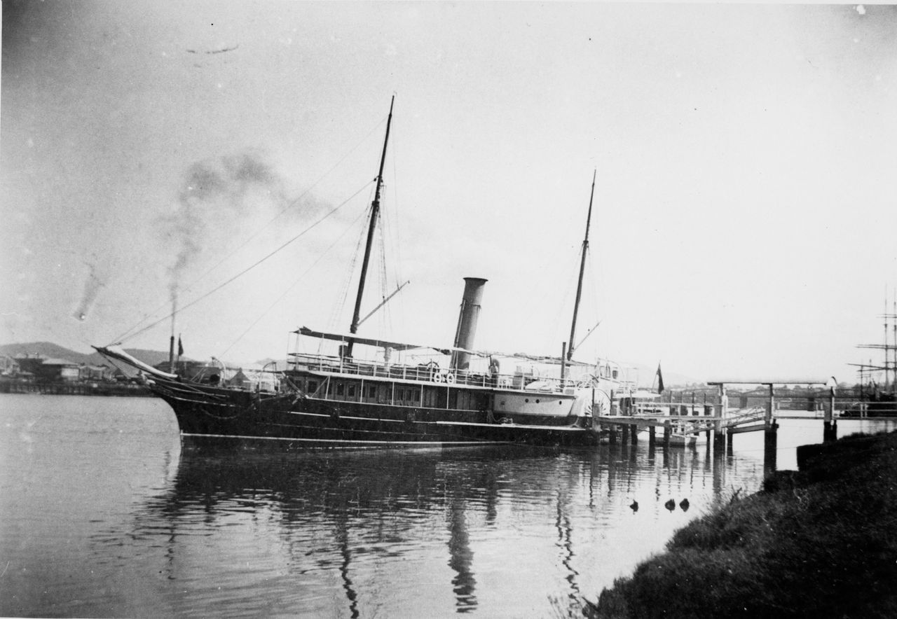 QGS Lucinda, c. 1890 (John Oxley Library, State Library of Queensland)
412 Stanley Street, South Brisbane
Get directions Queensland fleet, Paluma and Gayundah, at South Brisbane, undated (John Oxley Library, State Library of Queensland)
The Cliffs Boardwalk, adjacent to Dock Street, South Brisbane
Get directions Kangaroo Point Coal Wharves, c. 1900 (John Oxley Library, State Library of Queensland)