Banyo and Nudgee Heritage Trail
Discover the stories of Banyo and Nudgee, from farmland to post-war suburbs, on the self-guided heritage trail.

About the Banyo and Nudgee Heritage Trail
Explore the development of Banyo and Nudgee on a self-guided heritage trail.
There are 15 points of interest on this trail and include:
- the oldest surviving cemetery in the Brisbane area that remains in use
- the homes of local farming families
- a former Catholic orphanage that was run for more than 100 years.
Banyo and Nudgee Heritage Trail map
The trail is approximately 4.5 kilometres and takes approximately 1.5 hours to walk.
Start the route at the former St Vincent’s Orphanage in Nudgee and make your way toward Nudgee State School.
For addresses of all trail stops and suggested route between stops, download the trail guide.
Points of interest
131 Queens Road, Nudgee
Get directions
St Vincent’s Convent building, Nudgee, 1885 (National Library of Australia)
Before St Vincent’s Orphanage opened, orphaned and destitute children were housed at a government-run orphanage in Brisbane. From 1866-1867, the Sisters of Mercy took on the care of the Catholics amongst them, initially housing them in rented premises at New Farm.
This arrangement soon proved inadequate, and St Vincent’s Orphanage was established at Nudgee in 1867 by Bishop James Quinn. The site measured 3,500 acres and stretched all the way from today’s Queens Road to the waters of Moreton Bay. On 11 November 1867, the children were transferred from New Farm to this new site.
Accommodation initially consisted of rough slab huts, however by December 1866, a contract had been awarded for the construction of new buildings. These included dormitories for 80 children, a school room, a dining room, a reception room, a store room, a kitchen and staff residences.
Various extensions and additional buildings were added to the site over the years. Several of these buildings still survive today. The oldest building dates back to 1869, whilst the large, two-storey masonry building visible from Queens Road designed by Andrea Stombuco as a convent and chapel was completed in 1885. Three purpose-built timber orphanage dormitory blocks built in 1906 also survive.
The naming of St Vincents Road is a reminder of the early origins of this site.
Learn more about this Local Heritage Place.
Note
This is a private residence and is not open to the public.
493 St Vincents Road, Nudgee
Get directions
Aerial photograph of Nudgee Cemetery, Nudgee, 1946 (Brisbane City Council)
The very first cemetery established with the Penal Settlement in Moreton Bay was built in 1825. It was located at North Quay, near today’s Skew Street. This was followed in 1844 by the North Brisbane Burial Grounds at Milton, where Suncorp Stadium is now located. Nudgee Cemetery was built after these 2, but pre-dates the other major historic cemeteries in Brisbane, including South Brisbane, Nundah, Balmoral and Toowong.
The Roman Catholic Church owned a vast amount of land in the Nudgee District by the 1860s. The growing number of farming families in the district led to the need for a community cemetery. A portion of the Church’s land was set aside for this use.
The first burial at Nudgee Cemetery was Irish immigrant, Bernard McHugh, in June 1867. He ran a dairy farm adjacent to Nudgee Waterholes and died following a horse-riding accident. His grave can be found in the oldest section of the cemetery, alongside Childs Road.
While the cemetery was owned and run by the Catholic Church, it was open to others. People from any denomination were permitted to be buried there. Thousands of Brisbane residents have been buried in the cemetery over the last 150 years.
Notable citizens buried there include department store owner and philanthropist, T.C. Beirne, the former managing director of Castlemaine Perkins, George Wilkie Gray and the controversial Premier of Queensland and founder of the Democratic Labor Party, Vince Gair. It is the final resting place of many Brisbane Catholic clergy. This includes nuns from the Sisters of Mercy and Brother Patrick Ambrose Treacy, founder of the Christian Brothers in Australia.
Looking across the cemetery and out towards the south-west, a keen eye will observe the parapet of the former Pope Pius XII Seminary. Built on top of a hill, the seminary had commanding views across to Moreton Bay. During World War II, the bell tower in the main building was used by the Australian Army as an observation tower.
Learn more about this Local Heritage Place.
15 Hayden Street, Nudgee
Get directions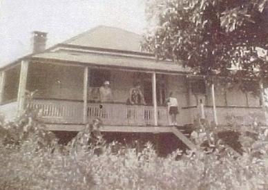
Child’s Residence on Hayden Street, Nudgee, Undated (Brisbane City Council)
David’s parents, Thomas and Mary Childs, were amongst the first free settlers to arrive in Queensland in 1849. They moved to Nudgee in 1866 and planted grape vines on their farm. The vines thrived in rich, friable loam and clay soil.
Their wines later won many awards.
The family named their farm ‘Childstone’ and, in addition to their residence, they also built cellars, where they offered tastings to visitors. A description in the Brisbane Courier in July 1884 paints a pleasant picture of the farm:
“A comfortable homestead stands in the vineyard, and is almost surrounded by date palms, bamboos, mango, and loquat trees, the place looking very pretty as approached from the Nudgee Railway Station.”
When Thomas died in 1881, his youngest son, David, managed the family business. At this time, the main varieties of grapes grown were White Pineau, White Hermitage, Tokay and Isabellas. The vineyard had been producing a local champagne since 1879, which had proved popular.
David married Lucy Jane Deagon in 1879 and they raised 7 daughters and 2 sons, building 15 Hayden Street in 1906. Their house became the winery headquarters and was the first residence in Nudgee to have a telephone. The Childs owned this house until 1919 and it remains as the last surviving connection to the Toombul Vineyards. The family is commemorated in the naming of Childs Road, which leads to the former winery site.
Although it was built in the Federation era, the design of the house more closely resembles the style of homes being built before the turn of the century. These houses featured pyramid or short-ridge hipped roofs.
They also had verandahs with a lower, separate roof from the main house. Although the verandah has been enclosed, these distinctive features are still visible.
Learn more about this Local Heritage Place.
Note
This is a private property and is not open to the public.
10 Hayden Street, Nudgee
Get directions Carew Cottage, Nudgee, Undated (Brisbane City Council)
The Carews were both Irish immigrants. They purchased the land on which the cottage sits in August 1886. It measured 32 perches (809 m2) and was part of 11 acres of former farming land, which had been subdivided into the 'Red Hill Estate’ by a local farmer, John Antonini. This was one of the first residential estates in the Nudgee area, and the first sales of the suburban-sized allotments were held in October 1884.
It is likely the Carews built this cottage on the site shortly after buying the land in 1886. Patrick Carew also appears to have leased or owned other land at Nudgee known as ‘Lander’s Pocket’, on the banks of what is now Kedron Brook. Although his occupation was recorded as labourer on various sources, he also seems to have agisted horses and cattle at Lander’s Pocket. In 1883 he registered the brand ‘PC5’, suggesting he also owned animals of his own.
Patrick met a tragic end in March 1903 whilst staying with his sister at Kangaroo Point, when he was found drowned in the Brisbane River. He was buried in the Nudgee Cemetery on 23 March 1903. Margaret remained living in Nudgee until her death in 1916.
The Carews had 12 children together, 6 of whom survived. Descendants of the Carew family and another local farming family, the Bennetts, retained ownership of the cottage until 2003.
It is one of the few remaining 19th Century timber cottages in Nudgee and is evidence of the early residential subdivision of the suburb.
Learn more about this Local Heritage Place.
Note
This is a private residence and is not open to the public.
26 Oakmere Street, Nudgee
Get directions%20(1).png/_jcr_content/renditions/cq5dam.web.1280.1280.jpeg)
Tender notice for Glendalough, in The Telegraph, 14 Sept 1889 (National Library of Australia)
George Hamilton purchased 4 allotments in John Antonini’s Red Hill Estate on 6 April 1886. The land ran between today’s Oakmere and St Achs Streets. The property changed hands a number of times in quick succession, before being bought by Albert Taylor in August 1889. The following month, he advertised tenders in the Telegraph newspaper for the construction of a wood cottage at Nudgee. In December 1889, Albert took out a £180 mortgage on his land.
It was most likely used to build his new house.
Martin Thomas Critchley purchased the house from Taylor in September 1892. Critchley was the caretaker and overseer for St Vincent’s Orphanage for many years. After his retirement from this position in 1912, he turned his hand to farming. He lived in the house with his wife, Mary Margaret, née Tumulty, whom he married in Ireland in 1875. The couple had 4 daughters together. Mary died in 1922 and the ownership of the property passed to her unmarried daughter, Mary Anastasia Josephine Critchley.
The property passed out of the Critchley family in February 1945, after 53 years. The new owners were the Jamesons, who sold off part of the land but retained the 32 perch block that contained Albert Taylor’s 1889 house.
Although similar to Carew cottage, ‘Glendalough” is a slightly larger and grander version of the style of house being constructed during this period, reflecting Taylor’s relative wealth.
Learn more about this Local Heritage Place.
Note
This is a private residence and is not open to the public.
18 Railway Street, Nudgee
Get directions
A Workers’ Dwelling house at Banyo, which is very similar to the one built for the Flemings, Banyo, 1912 (State Library of Queensland)
Thomas and Margaret Fleming purchased 3 lots of land along what would become Railway Street, Nudgee in February 1910. The property was part of James Robinson’s former farmland, which he had subdivided into residential allotments and sold as the Town of Nudgee Estate from 1882. This development was located immediately adjacent to the Nudgee Railway Station and included 3 streets, today’s Hayden, Oakmere and St Achs Streets.
The Fleming’s house was built through the Queensland Government’s Workers’ Dwellings Scheme, which provided those with limited means the opportunity to build a suitable dwelling. People building a house under this scheme could choose from several standard designs. Fleming's home closely resembles the Workers' Dwelling Type T from a catalogue dated 1911–1915. This ‘bungalow’ style roof, sweeping down in a continuous line from the apex of the roof to the edge of the verandah, became popular during the early part of the 20th Century.
The Flemings established a farm on this land as well. Their primary crop was pineapples, however by the 1930s they had branched out into watermelons. Members of the family lived in the house until the 1950s.
The Fleming Farm on Cribb Island Road was resumed as part of the Brisbane Airport expansion and by 1981 the original farmhouse there had been demolished. The house on Railway Street survives as a physical link to this early settler family.
Learn more about this Local Heritage Place.
Note
This is a private residence and is not open to the public.
44 St Achs Street, Nudgee
Get directions
Aerial photo showing St Achs Street and the army warehouses, Nudgee, 1946 (QImagery)
Like the Fleming Farmhouse on Station Street, this land made up part of the Town of Nudgee Estate which was subdivided in 1882. Frederick and Alice, née Bennett, married in 1900 and their only child, Ethel, was born the same year. The couple had already been living in the Nudgee area for a number of years when they purchased this land from William Joseph Cox Junior in June 1910.
A mortgage taken out on the property suggests the house may have been built around 1912. This home style, called 'Colonial Asymmetrical,' was most popular from the 1890s to about 1905. It may have been built earlier or considered old-fashioned when completed.¹. Key indicators of this style are the stepped roof over the verandah and the projecting room on one side, featuring a triple window and ‘flying’ gable. Fred was a carpenter and may have built the house himself. He may also have assisted with its construction.
The Coombs resided in the house together for many decades. After Alice died in 1931, Fred continued to live there until his own death in 1951.
During World War II, two US Army warehouses were built. They were located along the railway line on the western side of St Achs Street. Due to security concerns, no new buildings were permitted within the proximity of these warehouses. Numbers 40 and 44 St Achs Street were 2 of only 5 houses that had been built along that side of the street by 1946.
Learn more about this Local Heritage Place.
References
1. Rechner, Judy Gale and Brisbane History Group, Brisbane House Styles 1880 to 1940 : a guide to the affordable house, Brisbane History Group, Kelvin Grove, Queensland, 1998.
Note
This is a private property and is not open to the public.
40 St Achs Street, Nudgee
Get directions
Celia Cox's Certificate of Title for the property, 1885 (Land Titles)
Celia Cox, the wife of William Joseph Cox, purchased 2 allotments in the Town of Nudgee Estate in April 1885. Their son, William Joseph Cox Junior, bought the neighbouring 2 allotments to the north, which would become number 44 St Achs Street. Evidence suggests the cottage was constructed around 1888, however the Cox family does not seem to have ever lived there. Likewise, the next owner of the cottage, Isaac John Price, also seems to have purchased it as an investment. He bought it from Celia Cox on 10 February 1891 but resided elsewhere.
In February 1912, Price sold the house to William Luke Mitchell. Mitchell was already living at Nudgee at the time. When he died in 1925, his widow inherited the cottage. She owned it for another 14 years, but like the subsequent owners, Lance and Lyndia Clifford, rented it out to a number of tenants.
The cottage remains as a reminder of early land subdivision in this part of Nudgee. It also represents the affordable homes built across Brisbane in the late 1800s.
Learn more about this Local Heritage Place.
Note
This is a private property and is not open to the public.
348 St Vincents Road, Banyo
Get directions
The opening of the presbytery, The Brisbane Courier, 27 August 1928 (National Library of Australia)
The need for a presbytery was noted when the church opened. However, Brisbane architects Hall and Prentice were engaged after Reverend Brady’s appointment in February 1928 to design the residence. They were responsible for designing many houses and buildings in Brisbane, including Brisbane City Hall. Tenders for the construction of the presbytery were invited in April 1928, and R. Dempster was successful. The final cost of the building was £1,930, a large part of which was raised by the congregation. The presbytery was officially opened on 26 August 1928 and Reverend Brady moved in shortly after.
Brady served the local community until retiring in 1945. He died in 1951 and was buried nearby in Nudgee Cemetery. His replacement was Reverend Father Vince Carroll. Father Carroll saw the need for a school in the parish, and St Pius School was constructed in 1947 to meet the needs of the growing population. The school and presbytery have served as a religious and social centre for the Banyo Catholic community for decades.
Sadly, the original St Pius Church was destroyed by fire in 1976. A new place of worship was built on the same site, next to the presbytery. It was renamed the Church of the Holy Trinity.
Although the presbytery could easily be mistaken for a large private residence, the crosses in the windows on either side of the stairs are a reminder of the religious origins of the building.
Learn more about this Local Heritage Place.
Note
This is a private property and is not open to the public.
334 St Vincents Road, Banyo
Get directions
A manual telephone exchange, 1954 (State Library of Queensland)
Nudgee and Banyo experienced significant commercial and residential growth after the war. The population increased from about 400 in the 1920s to over 5,000 in the 1950s. As such, the telephone exchange was built to meet the growing needs of the community. It was one of 3 new automatic exchanges built in Brisbane at a cost of £90,000 and opened in December 1953. The others were at Chapel Hill and Bald Hills. A total of 310 telephone subscribers was transferred to the new exchanges.
The Nudgee Exchange replaced a temporary manual system that had been opened in June 1949. There were only 70 phone users in Nudgee at the time, and the exchange was constructed using switchboards recycled from the recently automated Toowong Exchange. These manual systems operated by the caller picking up their handset and requesting a number from the telephonist or ‘operator’ on the other end. The telephonist would then manually plug the line through to the required number using the switchboard. The new automatic exchanges removed the requirement for a telephonist, connecting the calls directly. The first automatic telephone exchange in Brisbane was built at South Brisbane in 1925.
The other larger building on the site was constructed in the early 1970s, representing a response to further population growth in the area and the associated increase in telephone usage.
Learn more about this Local Heritage Place.
Note
This is a private residence and is not open to the public.
302 St Vincents Road, Banyo
Get directions
Councillor William Bulcock Robinson, 1908 (Brisbane City Council)
William Robinson bought the parcel of land in August 1880 on which the house sits. He subsequently subdivided the land and sold part of it off, but retained a holding measuring more than 18.5 acres. It is thought to be around this time that the cottage was either built or relocated to the property. Robinson was already living at Nudgee by 1878 and the style of the cottage, with its very steep, gable-ended roof, is more typical of houses older than the 1880s. This suggests it may have been relocated onto Robinson’s land from elsewhere.
It is believed to have been built as a farmhouse using local bush timber. The house stumps were cut from local trees, and rough-edged timber hewn by an axe, adze or saw was used to construct the four-roomed cottage. The roof trusses were made from tea tree timber. Initially, the farmhouse roof was covered with timber shingles but later these were replaced by galvanised iron sheeting. As was common at the time, a detached kitchen was constructed at the rear of the cottage. There were open verandahs along the front and back of the cottage (now enclosed).
Robinson later became a Councillor for the Toombul Shire Council. He served as Chairperson of the Shire in 1910. Although his former home has been altered over the years, the old farmhouse remains a local landmark.
Learn more about this Local Heritage Place.
Note
This is a private residence and is not open to the public.
58 Meredith Street, Banyo
Get directions A sewerage plan showing the White Farmhouse, 1954 (Brisbane City Council)
White bought 2 large portions of land in January 1909, on the corner of St Vincents and Tufnell Roads. This land measured 36 acres in total and White amalgamated it into his family’s existing fruit farm, which was centred around Red Hill Road. It is thought that he built the cottage shortly afterwards as his residence. Although a simple, four-roomed cottage similar to the Carew Cottage, this home has a ‘bungalow’ style roof, like the Fleming Farmhouse. It shows the evolution of this type of affordable house after the turn of the century.
In 1918, White subdivided his land into housing allotments and sold off the majority of it. The cottage was retained on a double block and was purchased in 1920 by the Federal Deposit Bank Limited, along with all 28 lots between 2 unnamed streets. These would become Meredith (initially Margaret) and Paradise Streets. White remained living in Nudgee until his death at his residence on St Vincents Road in August 1927.
On 24 April 1925, Leslie and Doris Downey bought the 2 subdivisions containing the house. They owned the house for 4 years before selling it to William Andrew Cochin Watts in March 1929.
Although land subdivision and sales continued in the area, there were only 13 houses remaining along the entire length of the street by 1946. The cottage was the last house on the street and it remained surrounded by farm paddocks.
Learn more about this Local Heritage Place.
Note
This is a private residence and is not open to the public.
274 Tufnell Road, Banyo
Get directions
An extract from the Australian Electoral Roll showing members of the Blinzinger farming family living in the area, including George and Clara, 1912 (Australian Electoral Roll)
In November 1888, Rode purchased a large farm property at Nudgee that had been owned by Edward Tufnell for 25 years. Tufnell’s land ran between St Vincent’s and Earnshaw Roads, and the road that ran along the south of his land today bears his name.
In the 1890s, Rode borrowed money that enabled him to further develop his farm, including building a residence for himself. The house was built in 1893 and was originally located on Earnshaw Road.
Rode sold his farm to George Blinzinger in 1910. Blinzinger was a member of a large German migrant family that had arrived in Queensland in the 1860s. They owned farms and helped to develop the area.
On 2 August 1911, Blinzinger married Clara Christina Patzel. The Blinzinger’s small farm was typical of the type found throughout Banyo. They grew a variety of seasonal fruit crops, particularly peaches and mangoes, while the area now occupied by Earnshaw College was used to grow fields of sugar cane.
During World War II, the US Army built a major supply depot at the Tufnell and Earnshaw Road intersection. US troops would often visit the local farms to obtain private supplies of fresh fruit, vegetables and eggs.
The cottage was moved to Tufnell Road within the Blinzinger farm in 1954. The Queensland Government resumed much of the farm for the new Banyo High School site, now Earnshaw College. The cottage remained in the Blinzinger family until 2003.
Like the other 19th Century houses in the area, it features the standard steep, short-ridge pyramid roof and a separate roof over the front verandah. Before being renovated, the verandah extended around the right-hand side of the house. Although relocated and altered, the Blinzinger’s former home still stands as a reminder of this early farming family and their contribution to the development of the suburb. Blinzinger Road also remains as a tribute to this pioneering family.
Learn more about this Local Heritage Place.
Note
This is a private residence and is not open to the public.
425 Earnshaw Road, Banyo
Get directions Nudgee Methodist Church with the old church on the right, c. 1930 (State Library of Queensland)
By the 1920s, the original 1888 church building was becoming too small for the growing Methodists in the district. The church had been enlarged twice, with a 14-foot extension built in 1893 and a vestry added in 1900.
Initially it was proposed that a new site along Tufnell Road be purchased for the erection of a new church. However, in 1926, a decision was made to build a new church on the existing site. Queensland Government architect William Charles Nichols designed the new 60-foot by 30-foot church and the builder was Mr Hudson. The local community raised the money to pay for its construction and it opened on 27 August 1927. This community effort was later described as “a truly wonderful tribute to the sacrificial love and wholehearted service of the Nudgee Methodists”.
The old 1888 church building was retained and renovated for community use as a kindergarten, Sunday School and for social functions. Sadly, it was demolished in 1983. The building became the Nudgee Uniting Church in 1977 and is currently known as the Kenani Community Church.
Learn more about this Local Heritage Place.
Note
This is a private property and is not open to the public.
453 Earnshaw Road, Banyo
Get directions
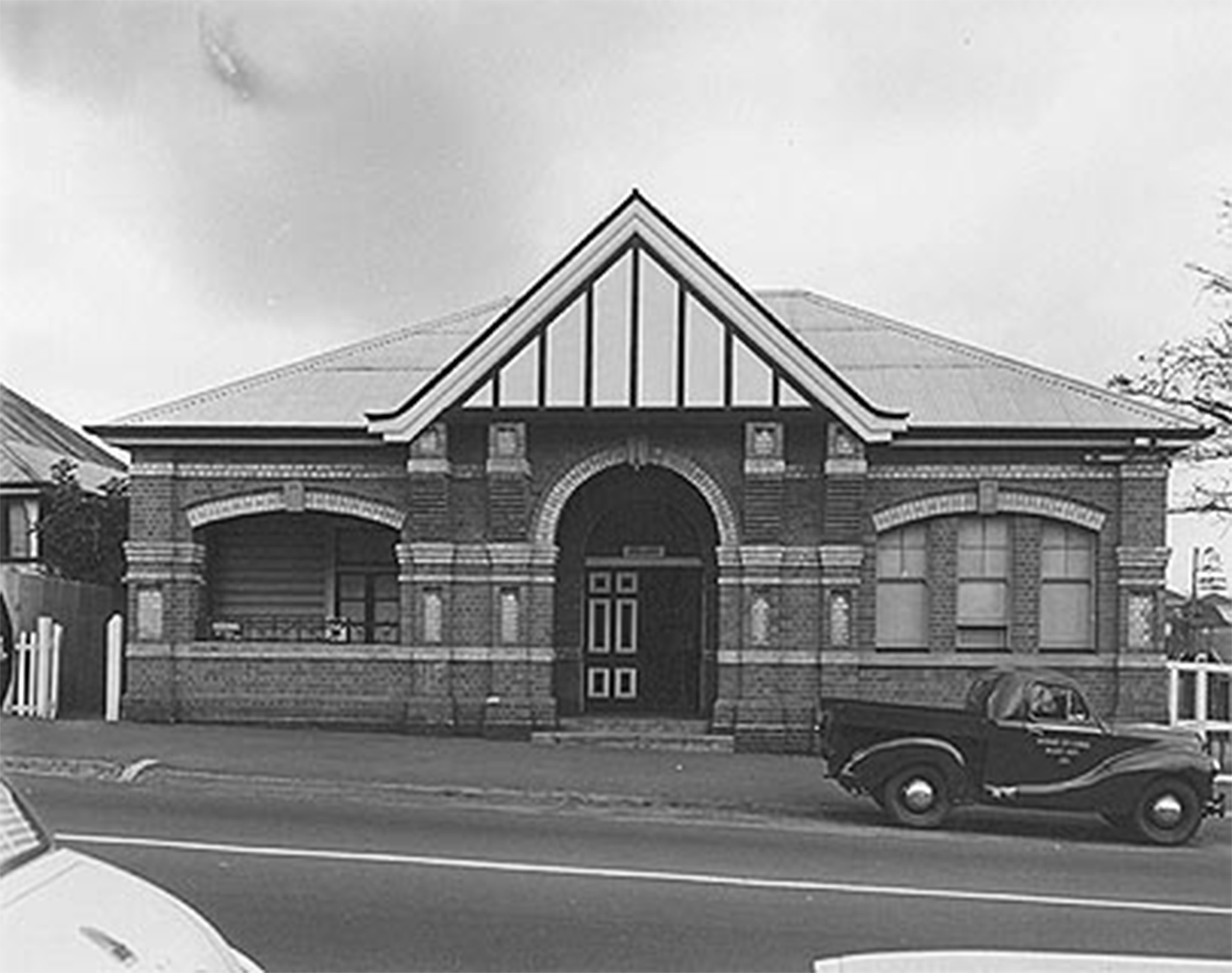
Earnshaw Road between Tufnell and Red Hill Roads with Nudgee State School on the right, 1959 (Brisbane City Council)
Residential growth after World War I made the old school building cramped. Residents wanted the school moved closer to Banyo or Nudgee townships near the railway stations. A local deputation went to the Minister for Public Administration on 29 March 1922 to request a new school. However, it took a number of years for a suitable site and funding to be obtained. Three acres of land along Northgate (later Earnshaw) Road were acquired from the Catholic Church. Funding for a new school building was approved in January 1928.
The new Nudgee State School building, with its three classrooms, cost ₤1785 and was opened in June 1928. This building became known as ‘A’ Block when more buildings were later added to the site. The primary school amalgamated with Banyo High School in 2003 and became Earnshaw College. Today the former A Block building is part of the Multicap disability support community.
Learn more about this Local Heritage Place.
Note
This is a private residence and is not open to the public.