Coorparoo and Holland Park Heritage Trail
Wander past architecturally important homes and buildings on the Coorparoo and Holland Park Heritage Trail.

About the Coorparoo and Holland Park Heritage Trail
View some of the impressive homes of Coorparoo and Holland Park on this heritage trail.
Both suburbs were part of the Coorparoo Shire, created in 1875. The district continued to grow as Brisbane’s population increased rapidly and moved to outlying areas.
The trail features excellent examples of Old English-style architecture that was popular during the interwar period, including:
- Catt’s House
- John Kindler's House
- the Bayard Residence.
Note: These properties are privately owned and not open to the public.
Coorparoo and Holland Park Heritage Trail map
The trail is approximately 4.4 km and takes an estimated time of 1.5 hours to walk
There is a steep incline, which can be avoided by leaving out stops 9 and 10.
For addresses of all trail stops and suggested route between stops, download the trail guide.
Points of interest
20 Percival Terrace, Holland Park
Get directions 'The Ideal Home of the Future’, 1936 (National Library of Australia)
In 1936, Leo Garton Catt purchased just over 20 perches of land on Percival Terrace, Holland Park in the Stonehaven Estate. Catt was a successful solicitor in Brisbane from the 1930s until well into the 1980s. He ran his own legal firm, L. G. Catt and Co.
In May 1936, plans for the construction of a new ‘brick and tile’ house on Catt’s Holland Park land were approved by Brisbane City Council. Later that year, he married Alma Hazel Forbes. The couple were popular in the Brisbane social pages with articles and photographs of the wedding featured in several newspapers. While on their honeymoon, their new family home was being constructed on Percival Terrace. It was completed by the end of 1936.
As befits a socialite couple, the design of the new house was very fashionable for the time. Catt commissioned prominent Brisbane architectural firm, Blackburne and Gzell, to design the house. Godfrey Blackburne and Vitaly Gzell established their practice in Brisbane in 1934 and continued their partnership until 1953. The firm became known for their designs in the latest interwar styles and designed some of Brisbane’s most fashionable interwar residences. They include several Old English and Spanish Mission designs in suburbs such as Ascot, Clayfield, Coorparoo, St Lucia and Holland Park.
The house was featured in a number of newspaper articles, including one titled 'Ideal Home for the Future’. The Catts resided in the house from the time it was built until the 1980s. It remained in their family until 1997.
For more information, visit Local Heritage Places.
Note
This is a private residence and is not open to the public. Please do not enter.
30 Percival Terrace, Holland Park
Get directions
John Kindler's House, 1970 (Corley Collection - State Library of Queensland)
Johannes Ernest Kindler, better known as John Ernest Kindler, was a leading figure in Queensland’s engineering history. He graduated from the University of Adelaide as an engineer in 1930, before working on the construction of the Sydney Harbour Bridge. From 1934, he worked as an assistant to the supervising engineer on the construction of the Story Bridge in Brisbane.
During the Second World War, Kindler was seconded to assist with the construction of coastal defences and marine facilities in Australia. After the war, Kindler gained several important engineering positions with the Queensland Government, including Deputy Chief Engineer of Hydraulics. In 1954, he was promoted to Chief Engineer and was involved in numerous important infrastructure projects.
Kindler played an integral role in advancing his profession and was awarded several prestigious awards for his engineering work. He sat on the board of the Faculty of Engineering at The University of Queensland and, in 1965, helped found the Queensland Institute of Technology (now Queensland University of Technology).
The plans for a new brick residence on Percival Terrace for Kindler were approved by Brisbane City Council in February 1936. No architect was recorded for the design of the house, however the builder was B. Hollingworth. By the early 1940s, the house had been completed. Kindler and his wife, Sara Kathleen, were living there.
Kindler died in 1968, but the Percival Street property remained in the family for a number of years afterwards. Like Catt's House, this striking brick and masonry home contributes significantly to the streetscape. It reflects the development pattern of fine houses in Holland Park during the interwar period.
For more information, visit Local Heritage Places.
Note
This is a private residence and is not open to the public. Please do not enter.
137 Abbotsleigh Street, Holland Park
Get directions
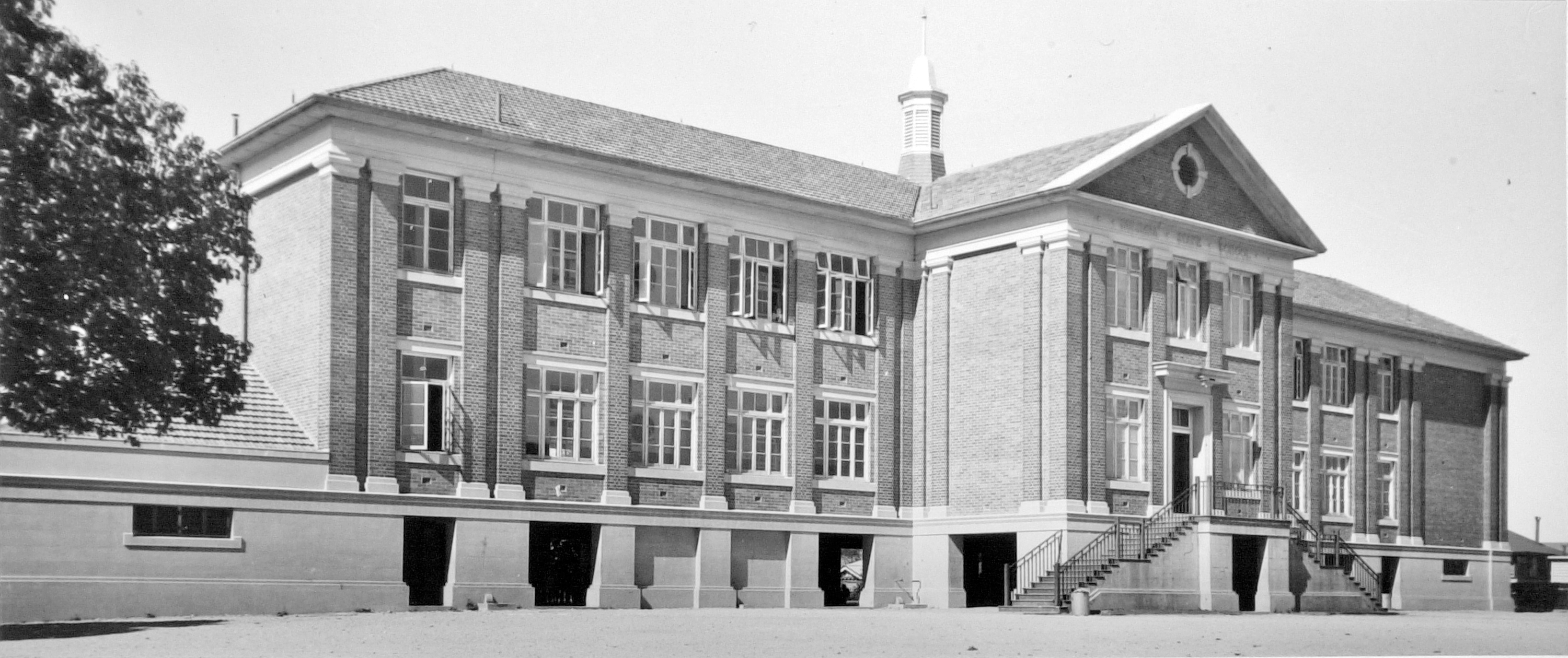
Holland Park State School, 1929 (Brisbane City Council)
In the mid-1920s, rapid population growth in the Holland Park area led to the need for a new school. Greenslopes State School requested more accommodation for the increasing enrolments, and local residents also petitioned the government. As a result, 3 acres of land were allocated to the school.
Despite an initially negative response from the District Inspector, the Department increased the school reserve from 3 to 5 acres. This change anticipated population growth in the area. The School Building Committee, formed by local residents, re-doubled its efforts to have a state school constructed on the Holland Park reserve. In 1928 , it succeeded in obtaining approval.
The school was completed that year and available for the first student intake at the beginning of 1929. The school was an L-shaped building that accommodated 120 pupils initially. However, the school outgrew its capacity in the first year. The 1930s saw several extensions and additions to try to keep up with student numbers.
While the most rapid growth of the school occurred in this early period, the highest levels of attendance were in 1955 (1,052 pupils) and 1958 (1,038 pupils). Construction of other state schools in the area led to declining enrolments. Numbers at Holland Park State School fell from this time.
The original 1928 building survives at the heart of the school, although it is no longer visible from the street.
For more information, visit Local Heritage Places.
Note
This is private property and is not open to the public. Please do not enter.
141 Abbotsleigh Street, Holland Park
Get directions
Sir William Flood Webb’s House featured in The Sunday Mail, 31 March 1940 (National Library of Australia)
In 1939, Oliver and Clarice purchased the land on the prominent corner site. McAnulty was recorded as both a cheese manufacturer and a merchant. In March 1939, he had plans by eminent Brisbane architect, Eric Percival Trewern, approved for his new home. Trewern had established his Brisbane architectural practice in 1920 and was renowned for his innovative Spanish Mission and Old English designs.
Trewern’s vision for the McAnulty home was very fashionable at the time and reflected their status and style. By March 1940, the house had been completed and the design of both the exterior and interior was featured in The Sunday Mail.
In 1945, the McAnulty family sold the property to Sir William Flood Webb. Webb was a highly significant figure in Australian history and made major contributions to the legal profession. His illustrious career included appointments as Queensland Solicitor-General, Queensland Supreme Court Judge, Chief Justice for Queensland and Justice of the High Court of Australia.
In 1943, Webb was commissioned by the Australian Government to investigate Japanese war crimes. He presented his findings in 1944 to the United Nations War Crime Commission in England. He later became President of the International Military Tribunal for the Far East. The tribunal investigated high-ranking leaders for their roles in war crimes. Webb described it as the most “important criminal trial in all history”.
Sir Webb moved out of the house in the late 1960s. The property remained in the Webb family until the 1980s.
For more information, visit Local Heritage Places.
Note
This is a private residence and is not open to the public. Please do not enter.
475 Cavendish Road, Coorparoo
Get directions Illustration promoting a certificate to be issued to the Anzac Workers who built the Anzac Cottages, 1918 (National Library of Australia)
The Anzac Cottage and TB Homes Scheme homes were usually built on donated land and constructed by volunteer labour, with much of the building material supplied at cost price by Brisbane businesses. Various community groups also contributed funds, such as the proceeds of school concerts and other fundraising activities.
Research suggests that the first Anzac Cottage in Brisbane was built in 1917 on the corner of Pullen and South Pine Roads, Everton Park. A pre-cut house was donated by the Brisbane timber firm of Brown and Broad, who launched their catalogue of ‘Newstead’ ready-to-erect houses in 1915.
The Anzac Committee was also responsible for determining who would occupy the houses. A prerequisite for occupancy was that the widow was to be of ‘good character’ and remain unmarried and respectable. She was to pay a small rent of £1/6 per week as well as Council rates and other expenses. The rent paid was to fund the ongoing maintenance of the cottages and if the widow remarried, she had to vacate the cottage.
A total of 38 Anzac Cottages were built in Brisbane, many of which were named commemorating notable Anzac locations or people. Only a small number of these special homes now survive.
For more information, visit Local Heritage Places.
Note
This is a private residence and is not open to the public. Please do not enter.
427 Cavendish Road, Coorparoo
Get directions
The former Loreto Convent building in use as the headquarters of the 101st Australian Convalescent Depot during the Second World War. The Casket Building is on the right, 1942 (Australian War Memorial)
The Catholic parish of Coorparoo and Ipswich Road was established in March 1913. It was the first parish to be created by Archbishop James Duhig, who recognised the need for a Catholic Church in Brisbane's south-eastern district. Duhig also invited the Sisters of the Institute of the Blessed Virgin Mary, also known as the Loreto Sisters, to found a school in the area.
In 1927, Archbishop Duhig purchased more than three acres of land on Cavendish Road from Edward Deshon, including the Deshon family’s residence, Kemendine. The building was converted into a convent and parish school and Loreto College was officially opened with 6 pupils on 26 January 1928.
The funding for a new school building which opened in 1931 had an interesting source. In 1929, a past pupil of the Loreto order gave the Sisters a Casket ticket that won £5,000. Hennesy, Hennesy & Co. architects were contracted to design what would become known as the ‘Casket Building’. It is no longer visible from the street but survives in the heart of the school.
In 1942, the Australian Army commandeered Loreto Convent as a convalescent hospital. The Loreto Sisters and their students were temporarily evacuated to Glen Innes in New South Wales. They remained there until the end of the war.
The substantial administration wing was constructed in 1953 and was opened by Archbishop Duhig on 23 May 1954. This is the large brick building with a bell tower that is visible from Cavendish Road.
The religious education centre (Gonzaga Barry building), designed by architect John Deshon and constructed in 1977, included wrought iron and timber from the demolished Kemendine. Cedar from the staircase of the old house was used to create the altar, lectern, crucifix and chairs. This building now remains in the centre of the school.
For more information, visit Local Heritage Places.
Note
This is private property and is not open to the public. Please do not enter.
398 Cavendish Road, Coorparoo
Get directions ‘Erica’ during WW2 when used as the 10th Camp hospital, 398 Cavendish Road, Coorparoo, 1942 (Australian War Memorial)
In 1925, the property was sold to Isiah and Edith Lahey, members of a well-known family of timber merchants. During the Second World War, the house and grounds were used as the 10th Camp Hospital in association with the 101st Australian Convalescent Depot at the nearby Loreto Convent.
In 1946, the Xavier Society purchased Erica from Mrs Isaiah Lahey for the establishment of a home for children with disabilities. The Xavier Home for Crippled Children opened on 15 May 1949. The home was run by the Franciscan Missionaries of Mary.
Although Catholic in origin, the home catered for children from any background. Many patients were suffering from the permanent paralysing effects of polio, which would not be eradicated in Australia until after the vaccine became available in the 1960s. The hospital expanded to fill much of the grounds of the house before ceasing operation in 1994.
In 2007, the hospital buildings were demolished, and the house was restored and adapted for community facilities to serve the adjoining retirement housing.
For more information, visit Local Heritage Places.
Note
This is private property and is not open to the public. Please do not enter.
189 Chatsworth Road, Coorparoo
Get directions
‘Camoola’, c. mid 2000s (Brisbane City Council)
Tessa Evelyn Thomas purchased more than 38 perches of land at Coorparoo in June 1926. She was already a widow by this date, her husband Frederick Michael Thomas having died in 1909.
A mortgage with the War Service Homes Commissioner was registered against the land 3 months after she bought it. Mrs Thomas was eligible for the loan due to her service as a nurse during the First World War. She enlisted in the Australian Army Nursing Service in November 1914 and served overseas in England, Belgium, Egypt and France. In recognition of her valuable service, she was awarded the Royal Red Cross.
In September 1926, she applied to the newly formed Greater Brisbane City Council for permission to build a new residence on her land at Coorparoo. On the 24 August 1926, Brisbane Courier recorded that the successful tender was by builder, A. M. Ford, at £1726.
Standard War Service Homes at the time ranged between about £550 to £1350 to build, so this represents a relatively expensive dwelling. It is possible that it was a custom design and was only partially funded by the mortgage. No architect for the property has been confirmed, but it may have been the work of the notable interwar architect, E. P. Trewern, as a number of his characteristic attributes are found in the home.
Shortly after the house was completed, Mrs Thomas married notable Brisbane surveyor, Cyril Francis Bennett (surveyor of the Holland Park Estate among others). The Bennetts named the house Camoola, a house name favoured by Mrs Thomas’ extended family in Victoria and New South Wales. It remained in the family until the 1980s.
For more information, visit Local Heritage Places.
80 Chatsworth Road, Greenslopes
Get directions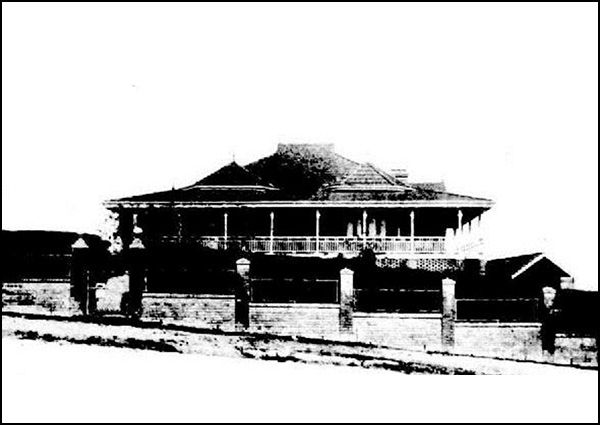
A photo of ‘De Aar’ published in The Queenslander, 10 September 1921 (National Library of Australia)
Development was also shaped by the construction of a tram line to the city in 1914. The Greenslopes tram terminus was directly across the road from De Aa’ and a shelter still remains in place.
The choice of the house name is interesting. De Aar is a town in South Africa’s Northern Cape province. Ethel’s father, railway engineer George Charles Willcocks, emigrated to South Africa in 1875 and spent the next 10 years constructing railway lines. One of these was an extension from Mynfontein to De Aar, which grew to become a significant interchange. This made it of particular importance to the British during the Boer War and a large base was established there. It seems likely that this family connection with a well-known military location was the reason for the choice of name.
Willcocks had purchased the land on the corner of Upper Cornwall Street and Chatsworth Road in 1890, and it remained in his ownership when De Aar was built. The large Federation-style house was constructed shortly after the Tait’s marriage in April 1915, suggesting that the land may have been a wedding gift from Ethel’s father. It was a choice location on top of a hill, with views in several directions. The house was conveniently located directly opposite one of the stops on the tramline to the city. The couple took up residence in their new home in September 1915. The property remained in the family until 1959.
For more information, visit Local Heritage Places.
Note
This is a private residence and is not open to the public. Please do not enter.
437 Upper Cornwall Street, Coorparoo
Get directions Bayard Residence photographed by Frank Corley,1970 (State Library of Queensland)
The house was built on land that was originally the tennis court of the neighbouring De Aar residence, which was subdivided and sold in March 1938. The new lot was purchased by Grace Elizabeth Bayard, the wife of Reginald Arthur Bayard. Shortly after, they applied for approval to build a new dwelling designed by architects Chambers & Ford, to be constructed by A.H. Gregory of Nundah.
Chambers and Ford had a previous connection with the Bayard family, having designed a distinctive and decorative Californian Bungalow for Reginald’s brother, Henry, in 1925.
Reginald and Henry were two of the “four capable sons” who managed the company, Bayards Ltd, a business founded in 1893 by George Arthur Bayard. By 1924, Bayard and Company, General Drapers and Manufacturers was recognised as one of the foremost drapery houses in Brisbane. After many decades of success, the company suffered during the Second World War and the post-war years, finally going into voluntary liquidation in February 1981. The firm had traded for 99 years but fell victim to changing buying patterns and drive-in shopping centres.
Reginald and Grace’s new house was featured in the 'Beautiful Queensland Homes' series in The Steering Wheel and Society & Home magazine. It was noted for its beautiful views and artistic colour scheme, with “gaily coloured bricks surmounted by plain white walls, relieved by green shutters and brick arches”. The coloured roof tiles were also mentioned as being unusual. The kitchen was “the last word in efficiency with a built-in refrigerator and hot water system”. The inclusion of a double garage underneath the house was also a very modern feature.
For more information, visit Local Heritage Places.
Note
This is a private residence and is not open to the public. Please do not enter.
343 Cavendish Road, Coorparoo
Get directions
A photograph of the first church in its original corner location, undated (St Stephens Anglican Church Coorparoo)
A meeting of Coorparoo residents in the Stephens Shire Hall on 4 May 1922 unanimously agreed to have a Church of England erected on the corner of Chatsworth and Cavendish Roads.
The site was purchased in 1921 by Reverend Saint Clare Donaldson, the first archbishop of Brisbane.The Building Committee, chaired by P. A. Blundell, had secured over half the funds for construction. The church was designed by honorary architect H. W. Atkinson, and tenders were called. The church was anticipated to be completed in 12 weeks and to cost approximately £1400. Reverend A. E. Smith, of Goondiwindi, was expected to take charge of the parish shortly after.
The completed church was dedicated and named after the martyr Saint Stephen on 8 October 1922. The Archbishop of Brisbane, Dr Sharp, assisted by Reverend Smith, performed the ceremony. He declared the church “a beautiful building,” surprising many that a wooden structure could look so good.
In November 1937, a parish hall was built on the site to house the increasing number of children attending Sunday school. The hall was 60 feet long and 30 feet wide and “fully equipped for social functions, with a roomy stage, and all necessary kitchen equipment”. The hall was later moved on the site, but continues to be a community hub, hosting countless social and community activities.
With a growing congregation in the post-war years, a larger and more modern church was required. The present brick church was subsequently designed by architect Horace Driver. It was completed and dedicated in 1958. To enable its construction, the original 1922 timber church was moved to the back of the lot, adjacent Stirrat Street, where it remains today.
For more information, visit Local Heritage Places.
Note
This is private property and is not open to the public. Please do not enter.
7 Mackay Street, Coorparoo
Get directions
The extent of Garnet Hill and Garnet Hill Estate, 1895 (Queensland State Archives)
Hugh William Elder Mackay was a clerk and accountant for the well-known firm of B. D. Morehead and Company, general merchants and stock and station agents. He married Mary Hillery on 28 November 1861. The couple had 9 children, 8 of whom survived to adulthood.
When it was built, Garnet Hill sat on a large parcel of land. The land extended all the way to Cavendish Road. The house faced the main road and, as a result, the part of the house now visible from Mackay Street is actually the side of the original house. A 1937 sewerage plan shows the house had a verandah wrapping around three sides. It also included a central entry landing and stairs.
The Mackays began selling off part of their land in 1885. The northern portion later became the Garnet Hill Estate. Today’s Mona, Emlyn and Brae Streets were part of this residential development.
After Hugh's death in February 1901, Garnet Hill was advertised for sale in the Brisbane Courier. The ad described it as a large residence with 7 rooms, kitchen, stable, and coach houses, occupying one of Coorparoo’s finest positions. At that time, the grounds of the estate measured more than 7 acres.
The family is commemorated in the naming of Mackay Street.
For more information, visit Local Heritage Places.
Note
This is a private residence and is not open to the public. Please do not enter.
312 Cavendish Road, Coorparoo
Get directions
Memorial Church of our Lady of Mount Carmel at Coorparoo, 1965 (State Library of Queensland)
The 1960s were an era of great change in the Catholic Church, following the Second Ecumenical Council of the Vatican, better known as Vatican II.
This series of assemblies occurred between 1962 and 1965. They responded to growing Catholic disenchantment with an insular Church in a modern, post-war world. It resulted in a number of changes to church traditions and the style of churches built. Mass was now delivered in English rather than Latin, with the priest facing the congregation. This led to changes in the internal layout of churches, with modern designs for the exteriors also being favoured.
The architecture firm Cullen, Fagg, Hargraves & Mooney were engaged to build the new church at Coorparoo. In April 1963, the foundation stone was blessed by Archbishop Duhig. The first service was held in March 1964, but it was not until June 1965 that the church was officially opened.
The church is unusual, because although built after the Vatican II with a strikingly modern exterior, the interior retained the traditional layout. Thus, the altar is at the front of the congregation faced by several linear rows of pews. This was at the request of the Carmelite Fathers.
The church design was recognised in 1965, when it was nominated for the Bronze Medal Award for the Building of the Year by the Queensland Chapter of the Royal Australian Institute of Architects. It remains a fine example of Modernist ecclesiastic architecture in Brisbane.
For more information, visit Local Heritage Places.
Note
This is private property and is not open to the public. Please do not enter.
342 Cavendish Road, Coorparoo
Get directions
‘Verona’, 1952 (State Library of Queensland)
Robert was born in Gladstone, Queensland, where his father was one of the earliest settlers. The Bell family were well-known in the cattle industry. He married the daughter of another grazier in the district, Jane Hill Stirrat, in October 1886. Shortly after, Robert and Jane moved to Brisbane, and Robert partnered with Hugh Stirrat to form a produce merchant business. However, it wasn’t until about 1893 that the Bells were living at Verona.
He may have moved here after establishing Alcock, Bell and Company. The firm produced leather goods and boots at its Stones Corner factory. It seems likely that much of the leather for these businesses would have been supplied from Robert and Jane’s family cattle properties.
Robert died at Verona on 25 September 1931. He lived and worked in Brisbane for decades. Yet his 1931 obituary in The Queenslander described him as “a retired grazier, well known in the Gladstone and Clermont districts.” His wife, Jane, died in 1943 and his 2 unmarried daughters remained living at the house.
Verona was advertised for sale in January 1951 as a “faithfully built, well-preserved spacious home, comprising lounge, dining, breakfast, 5 bedrooms, kitchen, bathroom, pantry, wide verandahs, etc.” and being “ideal for doctor or other professional man”.
It was purchased by Dr and Mrs Clark Ryan. They converted the house into a residence and doctor’s surgery, and established a clinic for the treatment of children. The house remains a medical practice.
For more information, visit Local Heritage Places.
Note
This is private property and is not open to the public. Please do not enter.
In front of 245 Chatsworth Road, Coorparoo
Get directions A similar shelter at Albion, 1950 (Brisbane City Council)
The extension of the tramline system to the Greenslopes, Coorparoo and Holland Park districts stimulated development in the area in the early decades of the 20th Century. The first part of the Logan Road tramline was opened in 1897.
A tramline was extended from Stones Corner along Logan Road and then down Chatsworth Road in 1914, and named the Greenslopes line. The main Greenslopes tram terminus was located on the corner of Chatsworth Road and Upper Cornwall Street, at the peak of the hill. Along the route, a number of tram shelters were built for waiting passengers.
In 1964, the tide began to turn against the tramway system. Reduced numbers of passengers and rising costs forced cuts in the frequency of many services. Also, the state government commissioned a comprehensive survey of Brisbane’s traffic requirements for the foreseeable future. The fate of trams and trolleybuses was sealed, as they stood in the way of proposed road widening and traffic islands and were seen to be inflexible, unlike the diesel bus.
On the night of Sunday 13 April 1969, the last tram passed along Queen Street, on its final run to the workshops at Boomerang Street, Milton.
This shelter is one of the larger, four-post styles, which are the most common remaining types across Brisbane. However, this one is a particularly good example because the original terracotta tiles still remain on the roof. Other local tram shelter examples can be found at 830 Logan Road, Holland Park, and 81 Chatsworth Road, Greenslopes. The latter is a particularly rare two-post design.
For more information, visit Local Heritage Places.